U.S. Weather/Crop Progress


Highlights:
- 47% of the corn is now harvested, up 17 points from last week, 5 points ahead of last year and 8 points ahead of the 5-yr average. Sorghum harvest is at 53%, 3 points ahead of last year and 3 points ahead of the 5-year average. Barley harvest is now completed. Soybean harvest is now at 67% completed, up 20 points from last week, 10 points ahead of last year and 16 points ahead of the 5-year average.
- The corn crop condition was steady from last week with the Good/Excellent rating at 64%. Sorghum condition was down 1 point in the G/E category at 44%, and 24% of sorghum is now rated poor to very poor condition due to excessive heat and dryness.
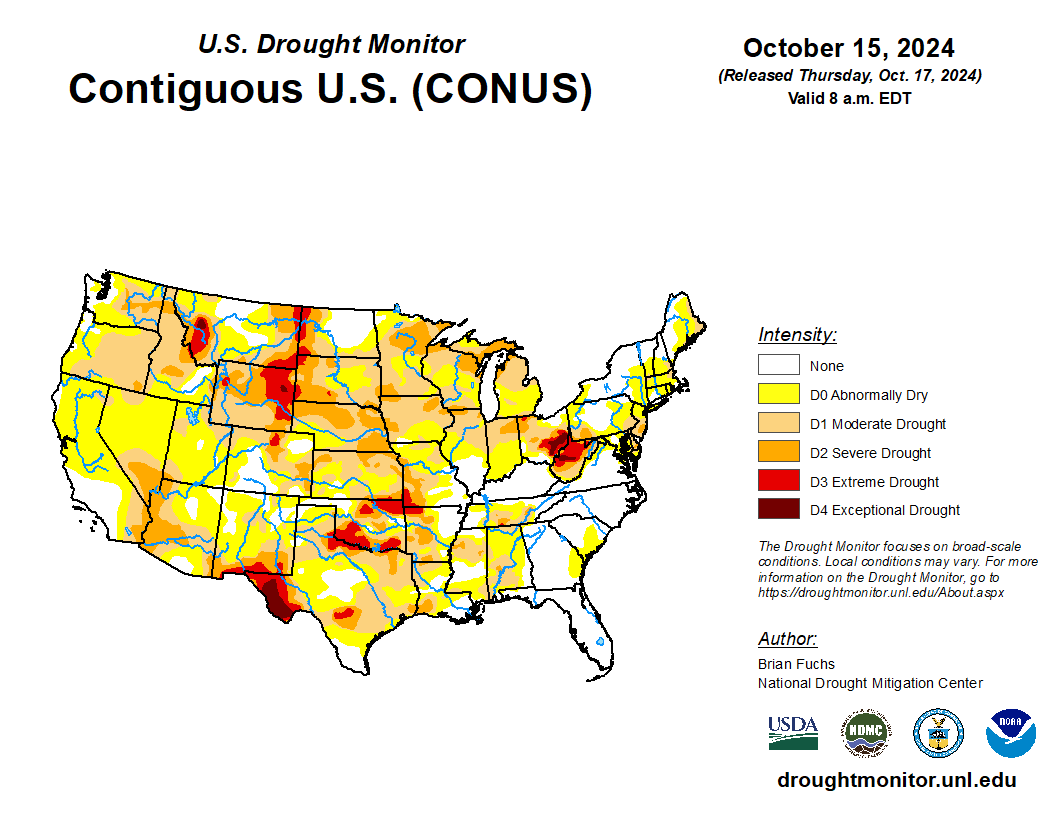
- In the West cooler air is overspreading California, the northern Great Basin, and the Northwest. Beneficial precipitation is developing across the Intermountain West and the Pacific Northwest. On October 13, prior to this precipitation, topsoil moisture was rated 93% very short to short in Wyoming, along with 77% in Oregon and 72% in Washington.
- On the Plains, temperatures are quickly rebounding in the wake of a recent cold snap, which ended the growing season as far south as northern Oklahoma. Later Thursday, high temperatures could top 85°F as far north as central South Dakota. Harvest activities generally continue at a rapid pace, with local disruptions due to dry, dusty conditions and an elevated wildfire threat. On October 13, topsoil moisture was rated at least two-thirds very short to short in all Plains States, except North Dakota.
- In the Corn Belt, frost and freezes occurred Thursday morning in many areas east of the Mississippi River. However, summer crops in the eastern Corn Belt are mature or have already been harvested. Meanwhile, warm, breezy weather is returning across the western Corn Belt, where today’s high temperatures should range from 70 to 85°F. However, fires during the harvest season are a concern in the western Corn Belt; on October 13, topsoil moisture was rated 86% very short to short in Nebraska, along with 76% in Iowa and 73% in South Dakota.
- In the South, cool, dry weather prevails, except for lingering showers along the middle Atlantic Coast. Scattered to widespread frost was noted Thursday morning as far south as Arkansas and northern sections of Mississippi, Alabama, and Georgia. In freeze-affected areas, most summer crops were mature or had already been harvested.
Outlook:
Cool weather across the eastern half of the U.S. will be gradually replaced by warmer conditions. Ongoing dry weather will accompany the Eastern transition to above-normal temperatures, except for occasional showers across Florida’s peninsula. Meanwhile, a record-setting, late-season Western warm spell will end during the next few days, as a cold front drifts eastward. By week’s end, the front should be draped across the Plains, preceded and accompanied by scattered showers. Precipitation could become more consequential during the weekend across central and southern sections of the Rockies and High Plains, while most other areas from the Pacific Coast to the Plains will receive only light rain or snow. The sudden transition to cooler, wetter weather across the western half of the U.S. should alleviate wildfire concerns and improve topsoil moisture. The NWS 6- to 10-day outlook for October 22 – 26 calls for the likelihood of above-normal temperatures nationwide, except for cooler-than-normal conditions from the Pacific Northwest to the northern Rockies. Meanwhile, below normal precipitation in much of the East and Southwest, as well as central and southern sections of the High Plains, should contrast with wetter-than-normal weather in many areas from the Pacific Coast to the northern Plains and upper Midwest.

