U.S. Weather/Crop Progress

Crop Condition Reports not applicable until Spring 2025.
Highlights:
- 81% of the corn is now harvested, up 16 points from last week, 13 points ahead of last year and 17 points ahead of the 5-yr average. Sorghum harvest is at 75%, 1 point ahead of last year and 2 points ahead of the 5-year average. Barley harvest is complete. Soybean harvest is now at 89% completed, up 8 points from last week, 7 points ahead of last year and 11 points ahead of the 5-year average.
- Crop condition reports for corn, sorghum, barley and soybeans will not be applicable until Spring 2025. Winter wheat conditions in the U.S. are showing effects from prolonged dryness with just 38% rating G/E compared to 47% at this time last year, and the Poor/Very Poor group at 23% versus 18% last year.
- In the West, precipitation associated with an approaching Pacific storm system has spread as far inland as the northern Rockies and as far south as northern California. Below-normal temperatures accompany the unsettled weather. Meanwhile, cool but dry weather favors autumn fieldwork, including cotton harvesting, in California and the Southwest.
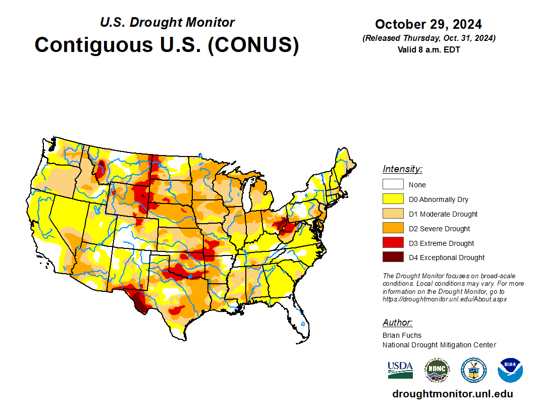
- On the Plains, cool weather prevails in the wake of a cold front’s passage. Freezes were noted early Thursday as far south as the southern High Plains, extending into the northern panhandle of Texas. Any recent precipitation associated with the cold front was largely confined to the eastern Plains, leaving many key winter wheat production areas still lacking soil moisture for proper autumn emergence and establishment. On October 27, winter wheat emergence was more than 5 percentage points behind average in Oklahoma, Nebraska, South Dakota, and Texas.
- In the Corn Belt, wet and sharply cooler weather has temporarily curtailed final corn and soybean harvest efforts. In parts of Minnesota and Wisconsin, precipitation has begun to change to wet snow. Any lingering warmth is confined to the eastern Corn Belt, in advance of an approaching cold front. Despite the sudden stoppage in fieldwork, many Midwestern producers are welcoming the month’s first meaningful precipitation. By October 27, dry autumn weather had left topsoil moisture rated at least 80% very short to short in Illinois, Iowa, Nebraska, Ohio, and South Dakota.
- In the South, shower and thunderstorm activity is spreading into areas west of the Mississippi River, slowing fieldwork but providing much-needed moisture for winter grains and cover crops. Meanwhile in the Southeast, warm, dry weather continues to promote summer crop harvesting, winter wheat planting, and hurricane recovery.
Outlook:
A cold front currently stretching from the Midwest into Texas will move eastward and weaken, with rainfall quickly diminishing in coverage and intensity while approaching and crossing the Appalachians. Meanwhile, a new storm system— and its attendant cold front—will arrive in the West during the weekend, reaching the Plains early next week. That system will also weaken before arriving in the eastern U.S. Consequently, there will be a sharp gradient between ongoing dry weather in much of the East and 5-day precipitation totals of 2 to 4 inches or more from the southern Plains into the upper Midwest. Much of the western U.S. will also receive some precipitation, including high-elevation snow, with the highest totals expected in northern California and the Northwest. The NWS 6- to 10-day outlook for November 5 – 9 calls for the likelihood of near- or below-normal temperatures in most areas from the Pacific Coast to the High Plains, while warmer-than-normal weather will cover the eastern half of the U.S. Meanwhile, near- or above-normal precipitation across most of the country should contrast with drier-than-normal conditions in the Pacific Coast States, western Great Basin, and along the middle and northern Atlantic Coast.

