U.S. Weather/Crop Progress


Highlights:
- 30% of the corn is now harvested, up 9 points from last week, 1 point behind last year and 3 points ahead of the 5-yr average. Sorghum harvest is at 43%, 2 points ahead of last year and 3 points ahead of the 5-year average. Barley harvest is now completed. Soybean harvest is now at 47% completed, up 21 points from last week, 6 points ahead of last year and 8 points ahead of the 5-year average.
- The corn crop condition was steady from last week with the Good/Excellent rating at 64%. Sorghum condition was unchanged in the G/E category at 45%, but 24% of sorghum is now rated poor to very poor condition due to excessive heat and dryness. The soybean condition rating held was down 1% at 63% G/E.
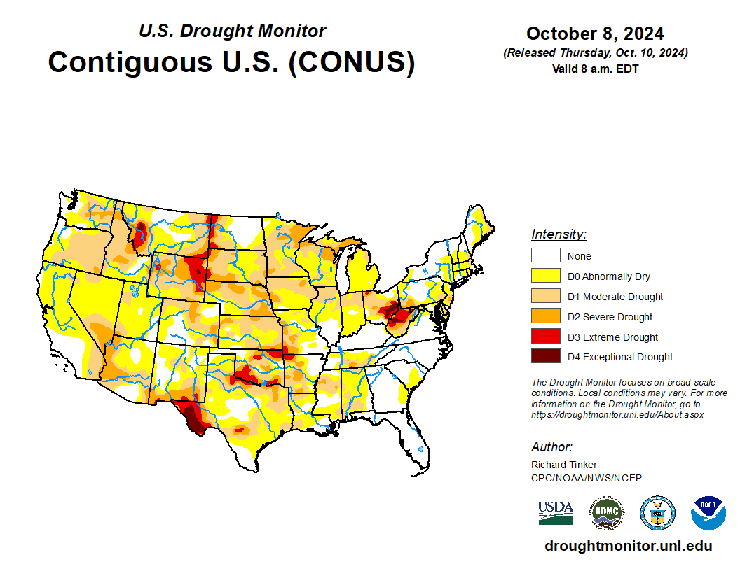
- In the West, a weak cold front is bringing cooler weather to the Pacific Northwest and northern Rockies, though showers are light and widely scattered. Northwestern producers need moisture for winter wheat; topsoil moisture was rated 70 and 75 percent short to very short in Washington and Oregon, respectively, as of October 6. Sunny skies and above-normal temperatures prevail elsewhere, maintaining high levels of stress on rangeland and pastures but favoring fieldwork.
- On the Plains, very warm and dry weather is promoting summer crop harvesting and winter wheat planting, with Thursday’s highs expected to approach or top 90°F from South Dakota to Texas. However, soil moisture remains limited for wheat establishment as Moderate to Severe Drought (D1-D2) has expanded across much of the region. A pocket of Exceptional Drought (D4) has developed in Wyoming, where topsoil moisture was rated 84% short to very short as of October 6.
- In the Corn Belt, dry and increasingly warm conditions prevail, with below-normal temperatures limited to the Ohio River Valley. Summer crop harvesting was progressing at a faster-than-normal pace across much of the region, though Moderate to Severe Drought (D1-D2) has expanded in recent weeks across the western and northern Corn Belt.
- In the South, Category 3 Hurricane Milton made landfall Thursday at 8:30 pm, EDT near Siesta Key, Florida, with peak sustained winds of 120 mph and a damaging storm surge. Just north of where the storm made landfall, up to 18 inches of rain fell near St. Petersburg, with the axis of heavy rain extending northeastward along the I-4 corridor. South and east of the eye, numerous tornadoes were reported. Elsewhere, dry weather favors autumn fieldwork as well as Southeastern Hurricane Helene recovery efforts, although drought has expanded across the Delta and western Gulf Coast region.
Outlook:
As of Thursday morning, Hurricane Milton was accelerating northeastward off the Florida Atlantic Coast as a Category 1 storm with maximum sustained winds of 85 mph. Rain associated with Milton on the Southeastern Coast will rapidly subside Thursday morning, giving way to dry weather which will aid recovery efforts in the storm’s wake. Meanwhile, a broad area of high pressure will maintain mostly dry weather across much of the country heading into the weekend. However, a strong cold front will bring sharply colder temperatures to the upper Midwest on Sunday and much of the eastern U.S. on Monday, although precipitation associated with the front — rain and perhaps even some wet snow — will be primarily limited to the Great Lakes and New England. The NWS 6- to 10-day outlook for October 15 – 19 calls for the likelihood of above-normal temperatures from the Pacific Coast to the Great Plains and upper Midwest, while cooler-than-normal conditions will prevail from the central Gulf Coast into New England. Near- to below-normal precipitation is expected across most of the U.S. save for wetter-than-normal weather along the Southeastern Coast and in the Pacific Northwest.

