
U.S. Weather/Crop Progress
Highlights:
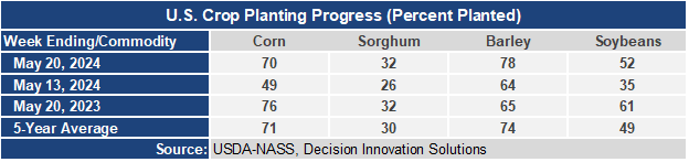
- For a week when there was significant rainfall across the Midwest, remarkable planting progress was made for corn and soybeans. Planting progress for barley and grain sorghum is ahead of the 5-year average. With heavy rainfall present across much of the Midwest this week, expect slow progress in planting progress in next week’s report. The share of the corn crop that will be “planted late”, after May 20th is roughly 30% of the crop.
- In the West, winter-like conditions are developing in parts of the northern Rockies, especially across southwestern Montana, where locally more than a foot of snow may fall by late Thursday. Meanwhile, dry weather and near-normal temperatures from California into the Southwest favor fieldwork and crop development.
- In the Plains, cool, mostly dry weather trails a departing storm system. In fact, scattered frost and light freezes were observed this morning from western North Dakota southward into eastern Colorado. The Plains’ most significant dry signal remains focused on southwestern Kansas and surrounding areas. From March 1 – Mary 21, precipitation in Garden City, Kansas, totaled just 1.03 inches (25 percent of normal). On May 19, nearly one-third (31%) of the winter wheat in Kansas was rated in very poor to poor condition, versus the national value of 18%.
- In the Corn Belt, the storm system responsible for Tuesday’s outbreak of severe weather in Iowa, Wisconsin, and portions of neighboring states has moved into south-central Canada. Early Wednesday, cool, dry weather prevails across much of the Corn Belt, although a few thunderstorms lingered in the Ohio Valley. Midwestern corn and soybean producers continue to make reasonably good planting progress between showers.
- In the South, early-season heat prevails in advance of an approaching cold front, which stretches from the lower Ohio Valley into central Texas. Along and near the cold front, thunderstorm activity is increasing. Meanwhile, warmth is promoting pasture growth, winter wheat maturation, and summer crop development. On May 19, Southern pastures were rated more than 60% in good to excellent condition, statewide, except in Florida and Texas.
Outlook:
Throughout the remainder of the week, the threat of severe weather will bounce around the central and eastern U.S., amid a series of poorly organized disturbances. Unsettled weather from the Plains eastward will persist through the Memorial Day weekend, leading to 5-day rainfall totals that will broadly reach 1 to 3 inches, with locally higher amounts. Similar precipitation totals can be expected in the Northwest, with some high-elevation sites receiving heavy, wet snow. In contrast, hot, dry weather will prevail during the next 5 days across the Deep South, from southern and coastal Texas to the southern Atlantic Coast. Dry weather will also prevail from California to the southern High Plains. The NWS 6- to 10-day outlook for May 27 – 31 calls for the likelihood of below-normal temperatures in much of the Midwest, while warmer-than- normal weather will dominate northern New England, the Deep South, and the West, excluding areas along the Pacific Coast. Meanwhile, below-normal precipitation across large sections of the West, as well as the northern Plains and upper Midwest, should contrast with wetter-than-normal weather in the southern and eastern U.S., not including Florida’s peninsula.
