U.S. Weather/Crop Progress
Highlights:
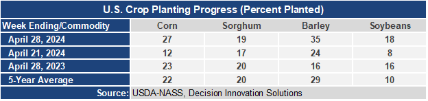
- Good planting progress was made for corn, soybeans, and barley last week with all currently ahead of last year’s progress and ahead of the 5-year average. With rainfall across much of the Midwest this week, expect a slowdown in planting progress in next week’s report.
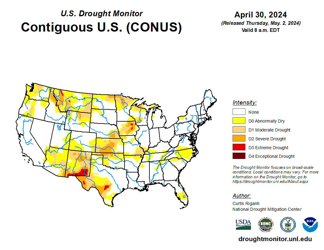
- In the West, chilly weather across the northern half of the region contrasts with above-normal temperatures from the Desert Southwest to the southern Rockies. Continuing a recent theme, spotty freeze warnings are in effect early today in the Northwest, including portions of Idaho’s Snake River Plain. A USDA/NASS report from Union and Wallowa Counties in Oregon indicated that recent sub-freezing temperatures “negatively impacted susceptible crops.”
- In the Plains, areas from Nebraska southward escaped Tuesday night’s severe weather with only scattered wind and hail damage. In addition to lingering pockets of drought on the central and southern Plains, worsening dryness is a concern in Montana, where topsoil moisture was rated 71% very short to short on April 28.
- In the Corn Belt, showers are mostly confined to the Great Lakes region. Elsewhere in the Midwest, dry weather between storm systems is promoting fieldwork, including corn and soybean planting. By April 28, nearly one-fifth (18%) of the intended U.S. soybean acreage had been planted, with some progress reported in all production states except North Dakota. At least one-quarter of the soybeans had been planted in Illinois (26%) and Iowa (25%).
- In the South, warm, mostly dry weather is nearly ideal for fieldwork and crop development. Any showers are confined to the mid-South and the southern Atlantic Coast. In recent weeks, a subtle drying trend in the southern Atlantic States left topsoil moisture (on April 28) rated 47% very short to short in Florida, along with 37% in North Carolina and 33% in Virginia and South Carolina.
Outlook:
Active weather will continue for the remainder of the week across the nation’s mid-section, as pulses of energy arriving from the western U.S. will spark heavy showers and locally severe thunderstorms. Five-day rainfall totals should reach 1 to 3 inches or more from the central and southern Plains into the middle and lower Mississippi Valley, with the hazards of high winds, large hail, and isolated tornadoes partially offset by the benefit of rain falling in remaining drought areas of the western Corn Belt and the central and southern Plains. Late in the week and during the weekend, showers will spread into the eastern U.S., although most areas will receive rainfall totaling an inch or less. Elsewhere, frequent showers will dot the northern half of the western U.S., while mostly dry weather will prevail from southern California to the southern Rockies. The NWS 6- to 10-day outlook for May 6 – 10 calls for the likelihood of below-normal temperatures across the northern High Plains and much of the West, while warmer-than-normal weather will dominate the central and eastern U.S. Meanwhile, below-normal rainfall from the southern Plains to Florida should contrast with wetter-than-normal conditions across the northern half of the country.