
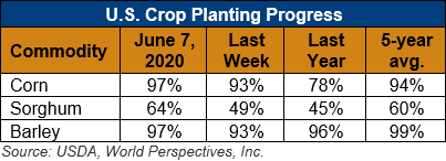
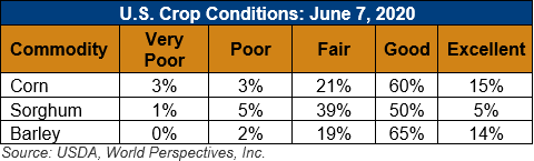
U.S. Weather/Crop Progress
U.S. Drought Monitor Weather Forecast: On June 11, a cold front is forecast to cross the eastern U.S. Surface high pressure, behind this front, is likely to result in mostly dry weather from the Appalachians west to the Rockies. Along with the dry weather, a return of above normal temperatures is likely across the central and southern Great Plains. From June 11-15, the heaviest precipitation (locally more than 1 inch) is forecast across the eastern Carolinas and Florida Peninsula. Following the heavy to excessive rainfall during early June, an extended period of dry weather is likely along the Gulf Coast. Seasonal dryness is forecast across the Southwest and California, while occasional light precipitation occurs across the Pacific Northwest.
The CPC 6-10 day outlook (June 16-20) indicates increased chances of above normal temperatures extending from the Great Plains northeast to the Great Lakes and New England with below normal temperature most likely across the northern Rockies. A large area with increased chances of below normal precipitation covers most of the Great Plains, Mississippi Valley, Corn Belt, and Gulf Coast States. A slight tilt toward above normal precipitation is limited to the mid-Atlantic, south Florida, and parts of the Pacific Northwest and northern Rockies. Above normal temperatures are favored throughout Alaska along with slightly elevated probabilities of above normal precipitation.
Follow this link to view current U.S. and international weather patterns and future outlook: Weather and Crop Bulletin.