
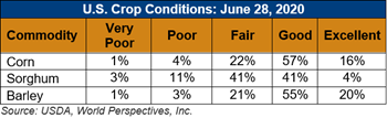
U.S. Weather/Crop Progress
U.S. Drought Monitor Weather Forecast: During the next 5 days (July 2-6), WPC’s QPF showed increased probabilities for precipitation across many of the northern tier states, much of the Mississippi Valley, and Southeast, where many areas are favored to receive up to and exceeding 1 inch of precipitation. The Northern High Plains and the Middle Mississippi Valley are expected to see some of the heaviest rainfall (2-4 inches in some cases). Probabilities drop off quite a bit for many locations just east of the Rockies, where below normal precipitation, high winds, low relative humidity, and above normal temperatures continue to be the driving factors for maintenance and exacerbation of drought conditions. Luckily, temperature anomalies are favored to be near to slightly above normal for much of the next week over the western Plains. Much of the Great Lakes is also favored to miss out on some beneficial rainfall in the upcoming week, in addition to positive temperature anomalies of 8-10°F.
The Climate Prediction Center’s 6-10 day outlook (July 7-11) shows an amplified pattern with a mean ridge over the central CONUS, and troughing over the West Coast and over the eastern CONUS. Enhanced probabilities of below normal temperatures are favored along the West Coast and interior Pacific Northwest, in association with a mean mid-level trough over the West. Above normal temperatures and below normal precipitation are favored in much of the central CONUS, with probabilities for above normal temperatures extending to the Great Lakes and Northeast, underneath a mean ridge. The active storm track is favored to continue for the northern tier states, with elevated odds for above normal precipitation centered over the Upper Midwest and Great Plains.
Follow this link to view current U.S. and international weather patterns and future outlook: Weather and Crop Bulletin.