U.S. Weather/Crop Progress
Highlights:
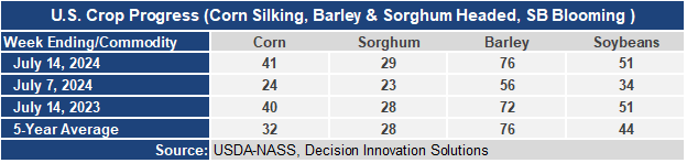
- 41% of the corn is silking which means that nearly half the corn crop is in the pollination stage. This is 17 points higher than a week ago, 1 point ahead of last year, and 9 points ahead of the 5-year average. Sorghum heading is at 29%, 1% ahead of last year’s and the 5-year average. Barley heading at 76% jumped 20 points this week and is 4 points ahead of last year and even with the 5-year average. Soybean blooming is at 51%, up 17 points from last week, the same as last year, but 7 points ahead of the 5-year average.
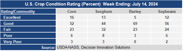
- The corn crop condition report held mostly steady this week with the Good/Excellent rating still at 68%. The sorghum condition rating slipped to 57% G/E, down 2 points from last week. The barley condition G/E rating improved 4 points this week to 70. The soybean condition rating remained at 68% G/E.
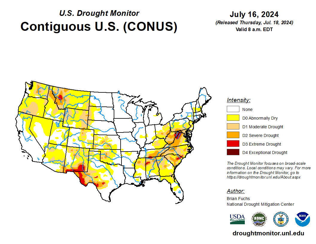
- In the West, as a mid-summer heat wave continues, dry thunderstorms remain a threat to spark new wildfires. Later today, lightning may be particularly active across portions of the Great Basin and northern Intermountain West. In Oregon, three active fires have charred more than 50,000 acres of vegetation—the 133,000-acre Cow Valley Fire northwest of Ontario, the 91,000-acre Falls Fire northwest of Burns, and the 69,000-acre Lone Rock Fire southeast of Condon.
- On the Plains, mostly dry weather prevails in the wake of a cold front’s passage. A hot spell has ended across the southern Plains, but significantly above-normal temperatures are arriving across the northern High Plains, including Montana. The northern High Plains’ heat favors summer crop development and winter wheat harvesting.
- In the Corn Belt, a high-pressure system centered over the upper Mississippi Valley is resulting in cool, dry weather, with today’s Midwestern maximum temperatures expected to remain mostly below 80°F. Summer crops in the Corn Belt remain generally in good shape, although corn and soybeans in still-soggy sections of the upper Midwest would benefit from warmer weather.
- In the South, unsettled, showery weather lingers along and south of a line from eastern Texas to the middle Atlantic Coast. Although the rain may be too late for some early-maturing summer crops, such as corn, most pastures and row crops are benefiting from the boost in soil moisture. On July 14, prior to this week’s rain, pastures were rated 63% in very poor to poor condition in Virginia, along with 55% in North Carolina, 47% in South Carolina, and 41% in Georgia.
Outlook:
Thunderstorms will remain active the next several days across the South, with 5-day rainfall totals expected to reach 2 to 6 inches from central and eastern Texas to the middle and southern Atlantic States. However, the precipitation will have a sharp northern edge, with dry weather expected into early next week from the middle and upper Mississippi Valley into the Northeast. Meanwhile, portions of the Plains may experience some late-week thunderstorms, widely scattered. In the West, heat re-intensification will accompany a diminishing chance of thundershowers, except in the southern Rockies, where the monsoon circulation will remain active. The NWS 6- to 10-day outlook for July 23 – 27 calls for the likelihood of near- or below-normal temperatures in the Pacific Northwest and a broad area centered over the central and southern Plains, southern Corn Belt, and mid-South, while hotter-than-normal weather will cover much of the northern and western U.S., as well as the Atlantic Seaboard. Meanwhile, near- or above-normal rainfall across most of the country should contrast with drier-than-normal conditions on the northern High Plains.