U.S. Weather/Crop Progress
Highlights:
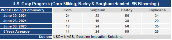
- 24% of the corn is silking which means the plants are entering the pollination stage. This is 13 points higher than a week ago, 6 points ahead of last year, and 10 points ahead of the 5-year average. Sorghum heading is at 23%, 1% behind last year’s and the 5-year average. Barley heading at 56% jumped 18 points this week, is even with last year and 3 points behind the 5-year average. Soybean blooming is at 34%, up 14 points from last week, 1 point behind last year, but 6 points ahead of the 5-year average.
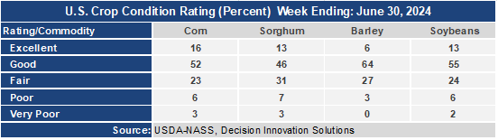
- The corn crop condition report moved up slightly this week with the Good/Excellent rating now at 68% as the excellent rating improved 1 point. The sorghum condition rating improved to 59% G/E up 1 point from last week and now is 4 points ahead of last year. The barley condition G/E rating improved 6 points this week to 70 and is now 18 points ahead of last year’s rating. The soybean condition rating improved 1 point to 68% G/E moving 1 point from the Good rating to the Excellent rating. The soybean G/E rating is 17 points higher than last year.
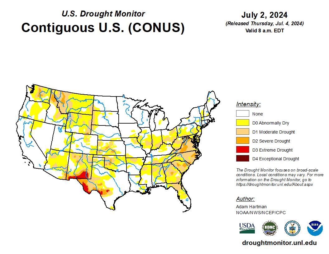
- In the West, a significant, mid-summer hot spell has lasted for more than a week, with all-time station records having been set in locations such as Palm Springs, California (124°F on July 5); Redding, California (119°F on July 6); and Las Vegas, Nevada (120°F on July 7). Heat-related agricultural impacts include heavy irrigation demands and an accelerating pace of development for Northwestern small grains.
- On the Plains, mostly dry weather accompanies a northwest-to-southeast transition to above-normal temperatures. Heat has already arrived across the northern High Plains, where Glasgow, Montana, posted a daily-record high of 103°F on July 10. Across the northern Plains, hot, dry weather is ideal for winter wheat maturation and harvesting. Hot weather is also hastening the development of spring-sown small grains, following a period of cool, showery weather.
- In the Corn Belt, mostly dry weather has returned, following the lower Midwestern passage of the remnants of Hurricane Beryl. The heaviest rain from Beryl, locally 2 to 4 inches or more, fell from south-central Missouri into southern Michigan, with corn and soybeans generally benefiting from the moisture, despite localized flooding. Early Thursday, a few showers—unrelated to the tropics—are occurring in northern Illinois and environs.
- In the South, a broad area of low pressure east of the southern Atlantic Coast is helping to focus rainfall across parts of Florida. A few showers are also occurring near the middle Atlantic Coast. Despite recent and ongoing showers, some significant pockets of Southeastern drought have left many summer crops such as corn, cotton, peanuts, and soybeans in need of additional moisture. Meanwhile in Texas, approximately 1.3 million electrical customers remain without power, 3days after Hurricane Beryl’s strike. Early Thursday, scattered showers are developing along and near the Texas coast.
Outlook:
Hot weather will prevail nearly nationwide during the next several days, with temperatures broadly approaching or reaching 100°F during the weekend and early next week as far north as the northern and central Plains, western and southern Corn Belt, and middle Atlantic States. In addition, above-normal temperatures will persist in much of the western U.S. Meanwhile, many areas of the country—including the Plains, West, and mid-South—will receive little or no precipitation during the next 5 days. Any significant Western rainfall should be confined to portions of the Four Corners States. Farther east, a tropical plume of moisture may contribute to heavy rain along the Atlantic Coast, including parts of Florida and from the Carolinas to southern New England. The NWS 6- to 10-day outlook for July 16 – 20 calls for near- or above-normal temperatures and rainfall across most of the country. Cooler-than-normal conditions will be confined to parts of the Great Lakes region and the Desert Southwest, while drier-than-normal weather should be limited to the Great Basin, interior Northwest, and an area along the Canadian border from the northern Rockies into the upper Great Lakes region.