U.S. Weather/Crop Progress
Highlights:
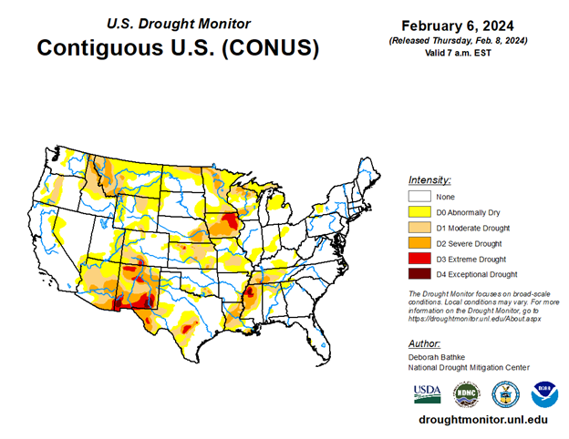
- In the West, California got hit with back-to-back winter storms, leaving many without electricity. Precipitation from these storms is moving further inland. Meanwhile, heavy snowfall at high elevations in the Southwest is improving the water supply in the area.
- In the Plains states, temperatures are cooler than last week but remain above normal in Montana and the Dakotas. Further South in the Central Plains, record setting warmth continues.
- In the Corn Belt, temperatures remain above normal. This is a notable change from the snowy conditions just a little over two weeks ago.
- In the South, the southern Atlantic region is experiencing dry, cool conditions. Texas recently received welcome precipitation to benefit their wintertime crops.
Outlook:
The current Pacific storm system is moving east across the U.S. The system is expected to cross the Rockies in the middle of the week and reach the Red River Valley by the end of the week. Snow is expected on the north side of the storm’s path in Montana and North Dakota.
Rainy weather is expected in the western U.S. through the end of the week, followed by cooler, drier conditions on the weekend. Rain is also expected to develop in the South late in the week.
The NWS 6- to 10-day outlook for February 12-16 calls for near- or below-normal temperatures nationwide, except for warmer-than-normal weather along the northern Pacific Coast and from the Eastern Dakotas to New England. Meanwhile, near- or below-normal precipitation over most of the country should contrast with wetter-than-normal weather across the northern High Plains, Florida’s peninsula, and portions of the south-central U.S.