U.S. Weather/Crop Progress
Highlights:
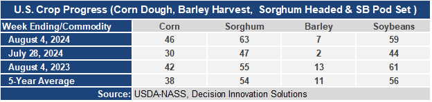
- 46% of the corn is now in the dough stage or ear-fill stage. This is 16 points higher than a week ago, 4 points ahead of last year, and 8 points ahead of the 5-year average. Heat in the Plains states is hastening maturity. Sorghum heading is at 63%, 8 points ahead of last year and 9 points ahead of the 5-year average. Barley harvest is underway with 7% harvested, up 5 points from last week, but behind last year and the 5-year average. Cooler than normal temperatures have slowed development. Soybean pod set is at 59%, up 15 points from last week, 2 points behind last year, but 3 points ahead of the 5-year average.
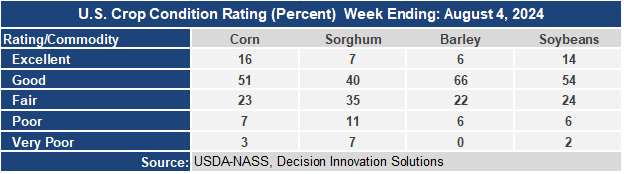
- The corn crop condition dropped 1 point this week with the Good/Excellent rating at 67%. Individual state reports show the crop deteriorating in the north and western parts of the Cornbelt but improving in the central and eastern Cornbelt. Sorghum condition dropped 8 points in the G/E category. 18% of sorghum is now rated poor to very poor condition due to excessive heat and dryness. The barley condition G/E rating rose 3 points to 72%. The soybean condition rating rose 1 point at 68% G/E.
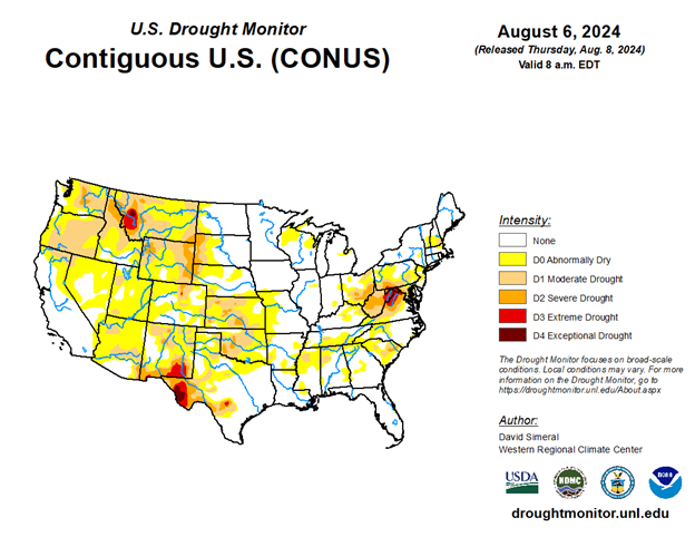
- In the West, showers associated with the Southwestern monsoon circulation are largely limited to the Four Corners States. Hot, dry weather covers much of the remainder of the region, with smoky, hazy conditions continuing to plague parts of the Northwest. The Park Fire, near Chico, California, has burned more than 420,000 acres of vegetation.
- On the Plains, cool air has pushed as far south as northern Oklahoma. Additionally, thunderstorms are producing generally beneficial rainfall on the central Plains. However, extreme heat persists across much of the southern Plains, where Thursday’s maximum temperatures ranging from 100 to 110°F will maintain stress on rangeland, pastures, and immature summer crops.
- In the Corn Belt, scattered showers and thunderstorms extend southwestward from the upper Great Lakes region. Thursday’s Midwestern high temperatures will vary widely, ranging from near 65°F in the Red River Valley of the North to 90°F or higher in parts of the Ohio Valley. Cool weather in the upper Midwest is maintaining a slow rate of corn and soybean development, but crop progress remains ahead of the 5-year average pace across the rest of the Corn Belt.
- In the South, Tropical Storm Debby drifted inland around 2 am EDT, about 20 miles northeast of Charleston, South Carolina. The threat of heavy rain and flash flooding is gradually shifting inland and farther north, in advance of Debby’s approach. Other areas of the South are experiencing hot, humid weather, with Thursday’s high temperatures expected to top 100°F in much of the western Gulf Coast region.
Outlook:
Tropical Storm Debby will soon lose tropical characteristics while accelerating northward across the Atlantic Coast States, but the flash flood threat will persist, with additional rainfall totaling 3 to 6 inches or more. Debby’s remnants will merge with a cold front, briefly enhancing rainfall in the Northeast. Many other areas of the country will remain dry during the next several days, except where the Southwestern monsoon circulation interacting with the tail of a cold front generates showers and thunderstorms across the Four Corners States and portions of the Plains. Cool weather will prevail into early next week across the Plains and Midwest, while heat will be mostly confined to the southern and western U.S. The NWS 6- to 10- day outlook for August 13 – 17 calls for the likelihood of near- or above-normal temperatures and rainfall across much of the country. Cooler-than-normal conditions will be confined to the Pacific Coast States and the western Great Basin, along with the middle Atlantic Coast and southern New England. Drier-than-normal weather should be limited to northern New England, the Great Basin and environs, and an area stretching from parts of Oklahoma and Texas to the central Gulf Coast region.