
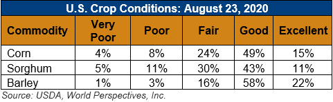
U.S. Weather/Crop Progress
U.S. Drought Monitor Weather Forecast: The NWS WPC 7-Day Quantitative Precipitation Forecast (QPF) calls for very heavy rainfall accumulations in association with Hurricane Laura making landfall along the Gulf coast of Louisiana and Texas. Along the coast, rainfall accumulations are expected to range from 3 to15 inches while areas inland in the Lower Mississippi River Basin are expected to see moderate-to-heavy accumulations (2-to-10 inches). In the Midwest, moderate rainfall accumulations (2-to-5 inches) are expected across parts of the region including Missouri, Iowa, Minnesota, Wisconsin, and Michigan as well as in parts of the Northeast. Out West, generally dry conditions are forecasted with the exception of some light precipitation (generally <1inch accumulations) in isolated areas of Arizona, New Mexico, and Colorado. Further northward, isolated mountain showers and thunderstorms are expected in the Northern Rockies of Wyoming and Montana with light accumulations (generally <1 inch).
The CPC 6-10-day Outlook calls for a moderate-to-high probability of above-normal temperatures in the Far West, Southwest, South, Southeast, and Mid-Atlantic states, while a high probability of below-normal temperatures are expected across the remainder of the West, Plains states, and the Midwest. In terms of precipitation, there is a moderate-to-high probability of above-normal precipitation across most of the eastern half of the U.S., Northern Rockies, and Alaska. Drier-than-normal conditions are forecast for the Pacific Northwest, Four Corners states, and the Gulf Coast region of Texas and Mississippi.
Follow this link to view current U.S. and international weather patterns and future outlook: Weather and Crop Bulletin.