U.S. Weather/Crop Progress
Highlights:
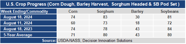
- 74% of the corn is now in the dough stage or ear-fill stage. This is 14 points higher than a week ago, even with last year, and 3 points ahead of the 5-year average. Sorghum heading is at 83%, 5 points ahead of last year and 3 points ahead of the 5-year average. Barley harvest is underway with 30% harvested, up 12 points from last week, but behind last year and the 5-year average. Cooler than normal temperatures have slowed development. Soybean pod set is at 81%, up 9 points from last week, 3 points behind last year, but 1 point ahead of the 5-year average.
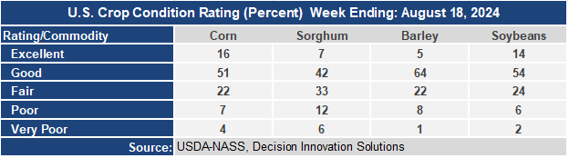
- The corn crop condition held steady this week with the Good/Excellent rating at 67%. This is the highest rating for mid-August since 2020. Sorghum condition declined a few points with the G/E category at 49%. 18% of sorghum is now rated poor to very poor condition due to excessive heat and dryness. The barley condition G/E rating remained at 69%. The soybean condition rating was steady at 68% G/E.
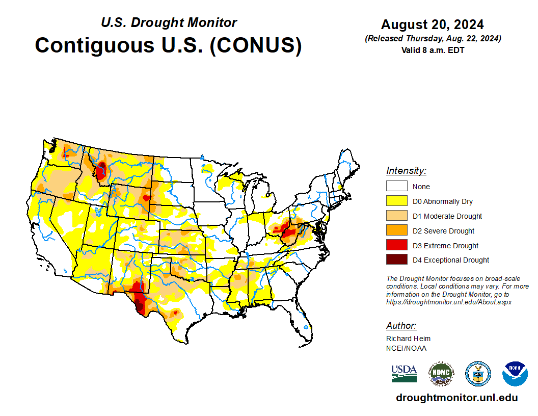
- In the West, monsoon showers continue from Arizona into Colorado, while showers associated with a slow-moving cold front are drifting into the Northwest. Moderate to Severe Drought (D1 and D2) has expanded across Washington and Oregon, where topsoil moisture was rated 69 and 81 percent poor to very poor, respectively, as of August 18.
- On the Plains, extreme heat across Texas (100-110°F) continues to adversely impact rangeland, pastures, and immature summer crops. The very hot and dry weather has also led to rapidly expanding drought across northern Texas, with statewide topsoil moisture rated 75 percent short to very short as of August 18. Conversely, locally heavy showers associated with a cold front are improving soil moisture for pastures and upcoming winter crop planting in Nebraska and northern Kansas, while cool and dry weather has settled over the northern Plains.
- In the Corn Belt, temperatures Thursday morning are averaging 10 to 15°F below normal across the Ohio River Valley and environs. Showers currently falling in the western Corn Belt are not expected to make much eastern headway, with protracted short-term dryness exacerbating drought in eastern Ohio.
- In the South, extreme heat persists in the western Gulf Coast region, where Thursday’s high temperatures will again approach 100°F. Florida is also experiencing hot, humid weather. Across the remainder of the South, however, dry weather and near- to below-normal temperatures are ideal for summer crop maturation and early-season harvesting, although topsoil moisture in Louisiana and Mississippi was rated 65 and 62 percent short to very short, respectively, on August 18.
Outlook:
A broad area of high pressure responsible for the recent dry and unusually chilly weather over much of the eastern U.S. will drift offshore, allowing 90- and 100-degree heat to expand north and eastward from Texas onto the central Plains and western Corn Belt, reaching the central and southern Atlantic Coast States over the weekend. However, dry conditions will persist save for showers along a weakening cold front in the western Corn Belt. Across the West, mostly dry but increasingly chilly weather will prevail, with precipitation primarily limited to monsoon showers in the Four Corners as well as showers associated with an upper air disturbance in the Pacific Northwest. The NWS 6- to 10-day outlook for August 27 – 31 calls for the likelihood of above-normal temperatures nationwide, though cooler-than-normal conditions are expected from the northern Intermountain West to the northern High Plains. Meanwhile, near- to below-normal rainfall will be centered over the lower Ohio and middle Mississippi River Valleys as well as the Northwest, while wetter-than-normal weather is anticipated over southern portions of Florida and Texas and from the Four Corners to the northern Plains and upper Midwest.