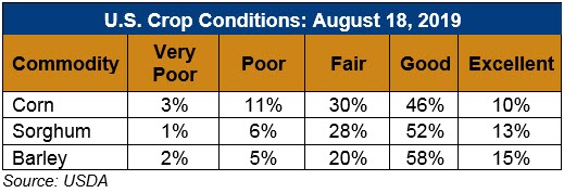
U.S. Weather/Crop Progress

U.S. Drought Monitor Weather Forecast: Over the week beginning Tuesday, August 20, according to NOAA’s Climate Prediction Center, dry conditions are expected to continue across much of the western half of the continental U.S. Some heavy rain may fall over parts of the Midwest and Southeast, with as much as five inches in areas of southern Iowa, northern Mississippi, eastern Nebraska, and parts of the Carolinas. Southern Louisiana may see up to seven inches. Looking further ahead to August 25-29, below-normal temperatures are favored across parts of eastern Montana, the Dakotas, Nebraska, Kansas, Minnesota, Iowa, and Missouri, while above-normal temperatures are forecast for parts of the Southern Plains and the Southwest. There are enhanced probabilities of above-normal temperatures for most southern coastal locations of Alaska due to above-normal sea surface temperatures. Near to below-normal precipitation is possible for the west, although parts of Southern California may see above-average rainfall. Rainfall may be above normal across the central and eastern U.S., except for parts of the Northeast. Above-normal precipitation is favored across northern and eastern Alaska, but may be below-normal across southwestern mainland Alaska and the Aleutians, where drought conditions prevail. Please note the forecast confidence for this period is average, according to CPC.
Follow this link to view current U.S. and international weather patterns and future outlook: Weather and Crop Bulletin.
