U.S. Weather/Crop Progress
Highlights:
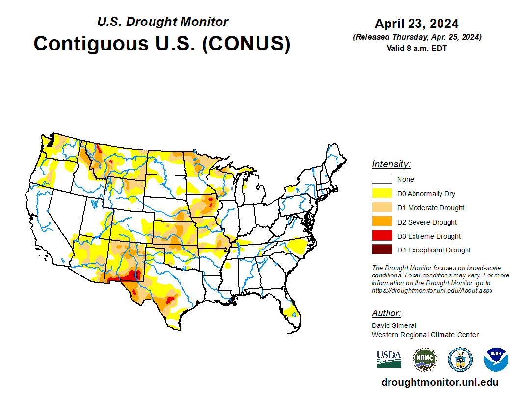
- In the West, near- or above-normal temperatures are ideal for fieldwork and crop and pasture growth. Most areas are experiencing dry weather, although a few showers are spreading ashore in the Pacific Northwest. With the snow-melt season underway, snowpack deficiencies persist across the northern tier of the western U.S.
- In the Plains, isolated showers are confined to areas from Kansas southward. However, portions of the central and southern Plains remain unfavorably dry, with increasing impacts on rangeland, pastures, winter grains, and emerging summer crops.
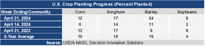
- In the Corn Belt, sub-freezing temperatures were reported Wednesday morning in the upper Midwest, extending as far south as northern Iowa. Although some corn and soybeans have been planted in the freeze-affected areas, little emergence has occurred. Dry weather throughout the Midwest favors spring fieldwork, except in areas where soils remain soggy.
- In the South, mild, mostly dry weather is promoting fieldwork and crop development. Winter wheat is developing at an ahead-of-normal pace, with 50% of the crop headed by April 21 in Arkansas (versus the 5-year average of 37%), along with 41% in North Carolina (versus the average of 31%).
Outlook:
A cold front currently crossing the northern Atlantic Coast will draw cooler air southward, with mid- to late-week freezes expected from the Great Lakes region into the Northeast. Meanwhile, back-to-back storm systems will traverse the western U.S. before tracking from the central Plains into the Great Lakes States. Five-day, two-storm rainfall totals should broadly reach 1 to 4 inches or more across the Plains, Midwest, and mid-South, with some of the highest totals expected from eastern sections of Kansas and Oklahoma into the middle Mississippi Valley. Locally severe thunderstorms, featuring high winds, large hail, and isolated tornadoes, will accompany the rain. However, significant rain will bypass several areas, including key winter wheat production areas of the southern High Plains. Mostly dry weather will also prevail in the Southeast. The NWS 6- to 10-day outlook for April 29 – May 3 calls for the likelihood of near- or above-normal temperatures and precipitation across most of the U.S. Cooler-than-normal conditions will be confined to northern California and the Northwest, while drier-than-normal weather should be limited to the southern Atlantic region, as well as an area stretching from the Great Basin to the central Rockies.