U.S. Weather/Crop Progress
Highlights:
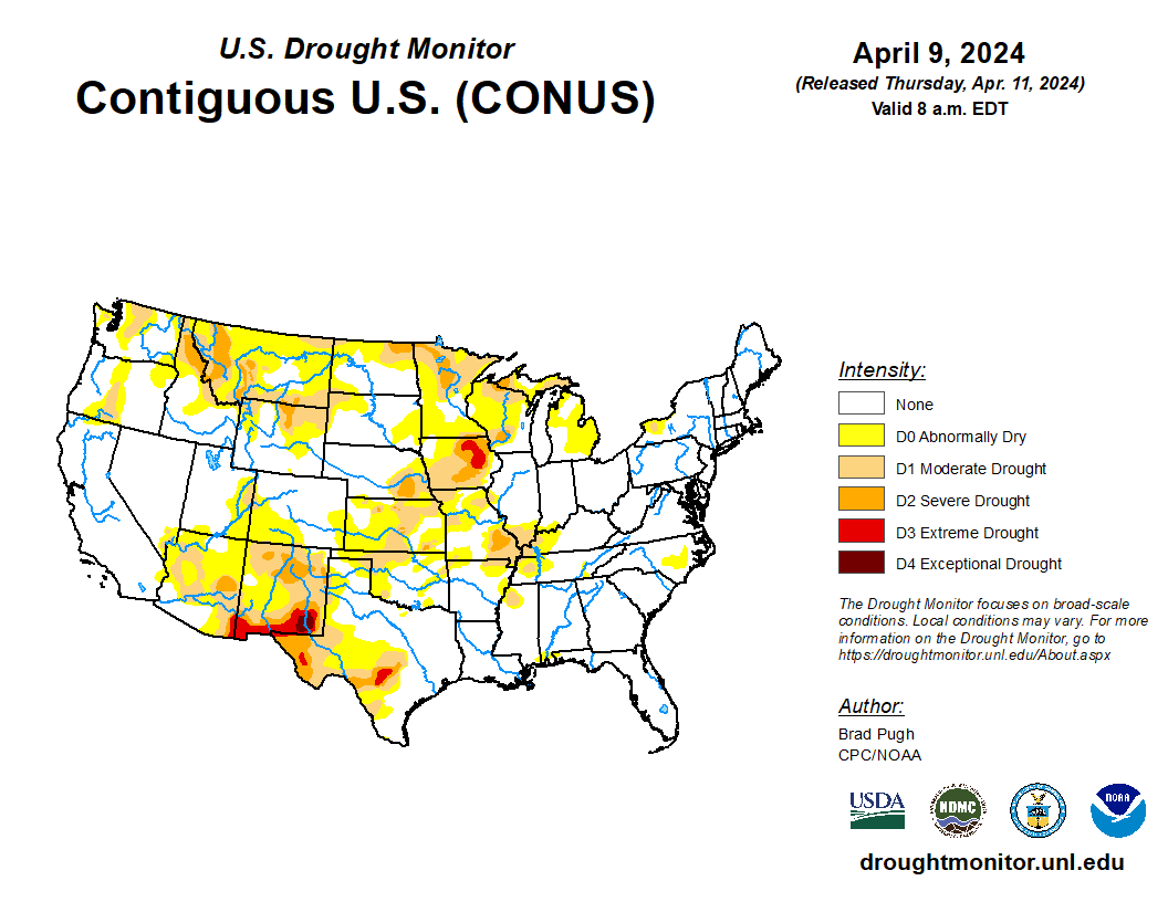
- In the West, warm, dry weather is promoting fieldwork and crop development. High temperatures on April 10 topped 80°F throughout California’s Central Valley and in parts of the Desert Southwest. Among major reporting states, California led the U.S. on April 7 with 40% of its winter wheat headed, well ahead of the 5-year average of 18%.
- In the Plains states, mild, mostly dry conditions favor spring fieldwork and winter wheat development. Any lingering showers on the southeastern Plains are gradually ending. On April 7, nearly one-third (30%) of the winter wheat in Kansas had jointed, while 60% of the wheat in Montana had broken dormancy. Respective 5-year averages were 17 and 33%.
- In the Corn Belt, rain showers are occurring along and southeast of a line from the middle Mississippi Valley to Lake Erie. The remainder of the Midwest is experiencing mild, dry weather, with Wednesday’s high temperatures ranging 60 to 75°F. Early-season fieldwork disruptions are becoming more widespread in the eastern Corn Belt, where topsoil moisture was rated 68% surplus on April 7 in Ohio, along with 35% in Indiana.
- In the South, localized flooding is occurring early today from eastern Texas to the Mississippi Delta, as heavy rain continues to fall on saturated ground. On April 7, prior to this rain event, topsoil moisture was already rated 22% surplus in Louisiana. Thunderstorms, some producing large hail and damaging winds, accompany the heavy rain.
Outlook:
A storm system currently crossing the western Gulf Coast region will drift northeastward, reaching the vicinity of Lake Huron late Thursday. The storm’s trailing cold front should clear the Atlantic Coast by Friday. The severe-weather threat will diminish slightly starting April 11 while shifting into the middle and southern Atlantic States, as well as parts of the Ohio Valley. Meanwhile, steady rain will spread from the mid-South into the eastern Corn Belt. Additional rainfall should reach at least 1 to 2 inches in much of the eastern one-third of the U.S., with higher amounts (2 to 4 inches or more) expected in thunderstorms across the Deep South. Although a few days of cool, blustery weather will trail the storm system, primarily across the Midwest and Northeast, much of the country will experience several days of warm, dry weather. Farther west, however, a new Pacific storm system will veer toward California before moving inland during the weekend. The NWS 6- to 10-day outlook for April 15 – 19 calls for the likelihood of near- or below-normal temperatures across the West and northern High Plains, while warmer-than-normal weather will prevail along and east of a line from New Mexico to the Dakotas. Meanwhile, near- or below-normal precipitation in the East and Far West should contrast with wetter-than-normal conditions from the Rockies to the western slopes of the Appalachians.