
U.S. Weather/Crop Progress
Highlights:
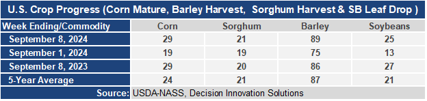
- 29% of the corn is now mature, up 10 points from last week, even with last year and 5 points ahead of the 5-yr average. Sorghum harvest is at 21%, 1 point ahead of last year and even with the 5-year average. Barley harvest is now 89% completed, up 14 points from last week, 3 points ahead of last year and 2 points ahead of the 5-year average. Soybean leaf drop is at 25%, up 12 points from last week, 2 points behind last year, but 4 points ahead of the 5-year average.
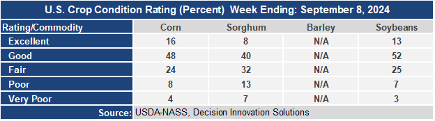
- The corn crop condition dropped 1 point this week with the Good/Excellent rating at 64%. A fall-off in crop condition with some hot, dry weather in the Midwest and Plains states would be seasonally normal. Sorghum condition dropped 2 points with the G/E category at 48%. 20% of sorghum is now rated poor to very poor condition due to excessive heat and dryness. The soybean condition rating held steady at 65% G/E. Five states (Arkansas, Illinois, Iowa, Louisiana, and Missouri) have soybean G/E ratings at or above 70.
- In the West, showers associated with a cold front are arriving in the Pacific Northwest. In advance of the front, windy, dry weather is leading to a significantly elevated wildfire threat in the Great Basin and Intermountain West; conditions also favor the fanning of any existing blazes. Elsewhere, a late-season heat wave is ending in the Pacific Coast States, but unusual warmth continues farther inland.
- On the Plains, an increase in cloudiness across Montana is signaling an impending pattern change. Elsewhere, warm, dry weather is promoting summer crop maturation and harvesting, as well as winter wheat planting. By September 8, the sorghum harvest was 10% complete in Oklahoma and was just getting underway (2% complete) in Kansas.
- In the Corn Belt, warm, dry weather is ideal for corn and soybean maturation. Throughout the Midwest, Thursday’s high temperatures will range from 80 to 90°F. The corn harvest has begun in parts of the southern Corn Belt, led by Missouri (13% harvested on September 8, versus the 5-year average of 4%).
- In the South, squalls and gusty winds are overspreading the central Gulf Coast region, with Hurricane Francine centered less than 200 miles southwest of Morgan City, Louisiana, at 8 a.m. EDT Thursday. The hurricane, with sustained winds near 90 mph, is moving northeastward at 12 mph, and appears to be heading directly toward Louisiana’s sugarcane area.
Outlook:
The National Hurricane Center forecasts Francine to make landfall late Thursday in southern Louisiana as a category 1 or 2 hurricane. A storm surge of 4 to 10 feet can be expected along and to the east of where Francine moves ashore, an area that includes Lake Pontchartrain. In the central Gulf Coast region, Francine should result in 4- to 8-inch rainfall totals, with locally higher amounts, leading to flash flooding and urban flooding. Significant damage from hurricane-force winds, 74 mph or greater, may occur in Francine’s eyewall during and immediately after landfall, with tropical storm-force winds (39 to 73 mph) spreading well inland. Crops in the path of Francine include southern Louisiana’s sugarcane, for which harvest has not yet begun; cotton, the majority of which has open bolls; and row crops such as rice and soybeans. Much of the remainder of the country—including large sections of the Plains and Midwest—will experience dry weather during the next 5 days, favoring fieldwork and summer crop maturation. In the Northwest, however, a cold front will generate some rain and high-elevation snow, with precipitation spreading as far east as the northern High Plains. The front’s passage will largely end a late-season Western hot spell, although triple-digit (100-degree) temperatures will linger in parts of the Desert Southwest. The NWS 6- to 10-day outlook for September 16 – 20 calls for the likelihood of near- or above-normal temperatures and precipitation across much of the country. Cooler-than-normal conditions will be confined to the Far West, while drier-than normal weather should be limited to coastal Texas, parts of the Southwest, and an area stretching from the Great Lakes region to New England.
