U.S. Weather/Crop Progress

Crop Condition Reports not applicable until Spring 2025.
Highlights:
- 95% of the corn is now harvested, up 4 points from last week, 9 points ahead of last year and 11 points ahead of the 5-yr average. Sorghum harvest is at 91%, 1 point ahead of last year and 2 points ahead of the 5-year average. Barley harvest is complete. Soybean harvest is now at 96% completed, up 2 points from last week, 2 points ahead of last year and 5 points ahead of the 5-year average.
- Crop condition reports for corn, sorghum, barley and soybeans will not be applicable until Spring 2025. Winter wheat conditions in the U.S. improved with widespread rains in the HRW wheat growing areas. G/E rating is 44% compared to 41% last week and 47% at this time last year, and the Poor/Very Poor group at 18% versus 23% last week and 17% last year.
- In the West, unsettled, showery weather lingers along the northern Pacific Coast. Dry weather covers the remainder of the western U.S. In many areas, fieldwork is winding down for the season, although cotton harvesting continues in Arizona (73% complete on November 10) and California (65% complete).
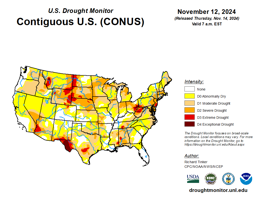
- On the Plains, mild, dry weather favors late-season fieldwork, except in areas where recent rain or snow was particularly heavy. Significant drought issues persist across portions of the northern Plains, where statewide topsoil moisture on November 10 was rated 81% very short to short in Montana, along with 77% in South Dakota. On the same date, 75% of South Dakota’s winter wheat had emerged (well behind the 5-year average of 90%), reflecting the dry conditions.
- In the Corn Belt, rain is falling early Thursday east of the Mississippi River, where most summer crops have already been harvested. Meanwhile, mild, dry weather covers the western Corn Belt, following recent rainfall. By November 10, Midwestern winter wheat planting ranged from 86% complete in Missouri to 100% in Michigan.
- In the South, showers spreading across the Appalachians into the southern Atlantic States are causing mostly minor fieldwork delays. In fact, the rain is highly beneficial in areas that have endured more than 6 weeks with little or no precipitation, since the passage of Hurricane Helene in late September. Farther west, mild, dry weather prevails from the western Gulf Coast region to the Mississippi Delta. In Louisiana, the sugarcane harvest was 48% complete by November 10, ahead of the 5-year average of 40%.
Outlook:
Generally beneficial rain showers will spread across the eastern U.S. today into Friday, although little or no precipitation will fall in parched sections of the Northeast where wildfires have been a problem. The focus for significant precipitation will soon return to parts of the western and central U.S. Initially, the heaviest rain and high-elevation snow will fall in the Pacific Northwest, although scattered, late-week showers may spread as far south as southern California. Late in the weekend and early next week, a significant precipitation event will unfold across the nation’s mid-section, with an axis of 1- to 4-inch totals expected from southern sections of the Rockies and Plains into the upper Midwest. Elsewhere, Tropical Depression Nineteen has formed over the western Caribbean Sea, with no immediate threat to the U.S. Gulf Coast—though the system could still enter the Gulf of Mexico next week, following extensive land interactions with Central America and the Yucatan Peninsula. The NWS 6- to 10-day outlook for November 19 – 23 calls for the likelihood of near- or below-normal temperatures across much of the western and central U.S., while warmer-than-normal weather will prevail along and east of a line from Minnesota to Alabama. Meanwhile, near- or below-normal precipitation from the Pacific Coast to the Plains and Mississippi Delta should contrast with wetter-than-normal weather in the East and much of the Midwest.

