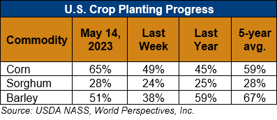
U.S. Weather/Crop Progress

U.S. Drought Monitor Weather Forecast: Showers and thunderstorms will linger for the next couple of days across the lower Southeast, in the vicinity of a weakening cold front, with an additional 1 to 3 inches of rain possible in some areas. Meanwhile, another cold front will race eastward across the northern U.S., generating showers before reaching the Atlantic Coast on Saturday. Rainfall associated with the Northern cold front will be short-lived, with most locations receiving less than an inch. However, late-week thunderstorms may become heavy along the tail of the cold front, with 1 to 3 inches of rain possible in central and southern sections of the Rockies and Plains. Elsewhere, little or no precipitation will fall during the next 5 days along and near the Pacific Coast.
The NWS 6- to 10-day outlook for May 23 – 27 calls for the likelihood of near- or above-normal temperatures and precipitation across most of the country. Cooler-than-normal conditions will be confined to parts of the South, while drier-than-normal weather should be limited to the Pacific Northwest and an area stretching from the mid-South and lower Midwest into the Northeast.
Follow this link to view current U.S. and international weather patterns and future outlook: Weather and Crop Bulletin.
