
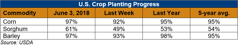
U.S. Weather/Crop Progress
U.S. Drought Monitor Weather Forecast: For the 5-day period June 7-11, 2018, the northern and eastern CONUS are generally predicted to receive 0.5-1.5 inches of rain. Heavier amounts are forecast over portions of the western Corn Belt, the southern Great Lakes region, and the Florida peninsula. A relative maximum of 3-4 inches is possible in Iowa, likely due to nocturnal thunderstorm clusters (MCS) which are common at this time of year. Little to no precipitation is expected elsewhere during this period. For the subsequent 5-day period (June 12-16, 2018), CPC predicts elevated odds of above normal rainfall across the southern CONUS, with a weak tilt toward above running northward across the Mississippi Valley and eastern Great Plains region. Elevated odds of below normal rainfall are highlighted over the Northwest, the northern High Plains, and most of the Atlantic Coast states from Maine to Virginia.
Follow this link to view current U.S. and international weather patterns and future outlook: Weather and Crop Bulletin.