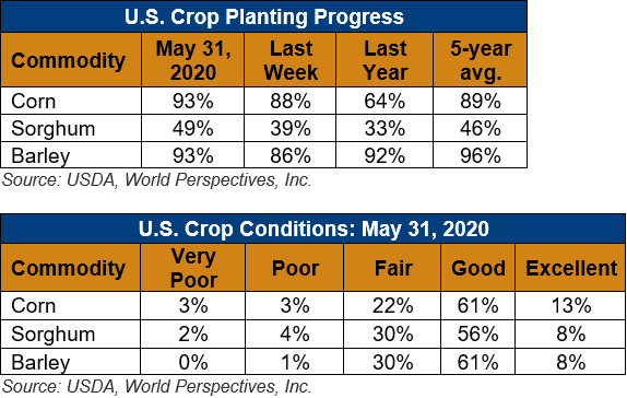
U.S. Weather/Crop Progress

U.S. Drought Monitor Weather Forecast: As of the afternoon of Wednesday, June 3, the National Weather Service Weather Prediction Center is forecasting dry weather to continue over the southern Great Plains and the central and southern high plains from June 4 to the evening of June 8. Heavy precipitation is possible from the central Gulf Coast eastward into the Florida Peninsula. Through the evening of June 10, heavy precipitation is also possible in the Mississippi River Valley, as well as eastern portions of Nebraska, North Dakota, and South Dakota. Some of the forecast rainfall will likely be dependent on the evolution of Atlantic tropical cyclone Cristobal. Please monitor forecasts from your local National Weather Service office and the NWS Weather Prediction Center for rainfall forecasts and for information on possible hydrological impacts from Cristobal. For the latest information on Cristobal, please refer to information and forecasts from the National Hurricane Center.
The Climate Prediction Center is forecasting increased chances for warmer than normal temperatures in California and across southern New Mexico, Texas, Louisiana, and the southeast Atlantic and Gulf Coasts for June 9-13. Meanwhile, near-normal or below-normal temperatures are forecast over much of the rest of the continental U.S. during this period. Increased chances for above-normal precipitation are forecast in the eastern and central United States as well as in the Pacific Northwest, while increased chances for below-normal precipitation are forecast in the High Plains, Texas, Oklahoma, and the Rocky Mountains.
Follow this link to view current U.S. and international weather patterns and future outlook: Weather and Crop Bulletin.
