U.S. Weather/Crop Progress
Highlights:
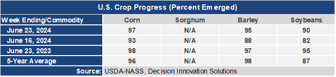
- 97% of the corn planted has emerged. This is 4 points higher than a week ago, 1 point behind last year, but 1 point ahead of the 5-year average. Soybean emergence is at 90%, up 8 points from last week, but 5 points behind last year, although 3 points ahead of the 5-year average.
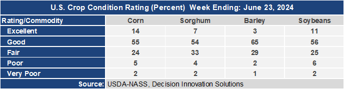
- The corn crop condition report has now dropped several points from the initial rating with the Good/Excellent rating now at 69%. The soybean condition rating has dropped to 67% G/E. The sorghum condition rating is now at 61% and the barley G/E condition rating is at 68%.
- In the West, chilly, showery weather is overspreading the Northwest behind a strong cold front. Farther south, cooler but sunny weather in California is promoting fieldwork and crop development. Meanwhile, widespread showers enhanced by moisture from the Southwest monsoon have developed from the northern Rockies into the lower Four Corners.
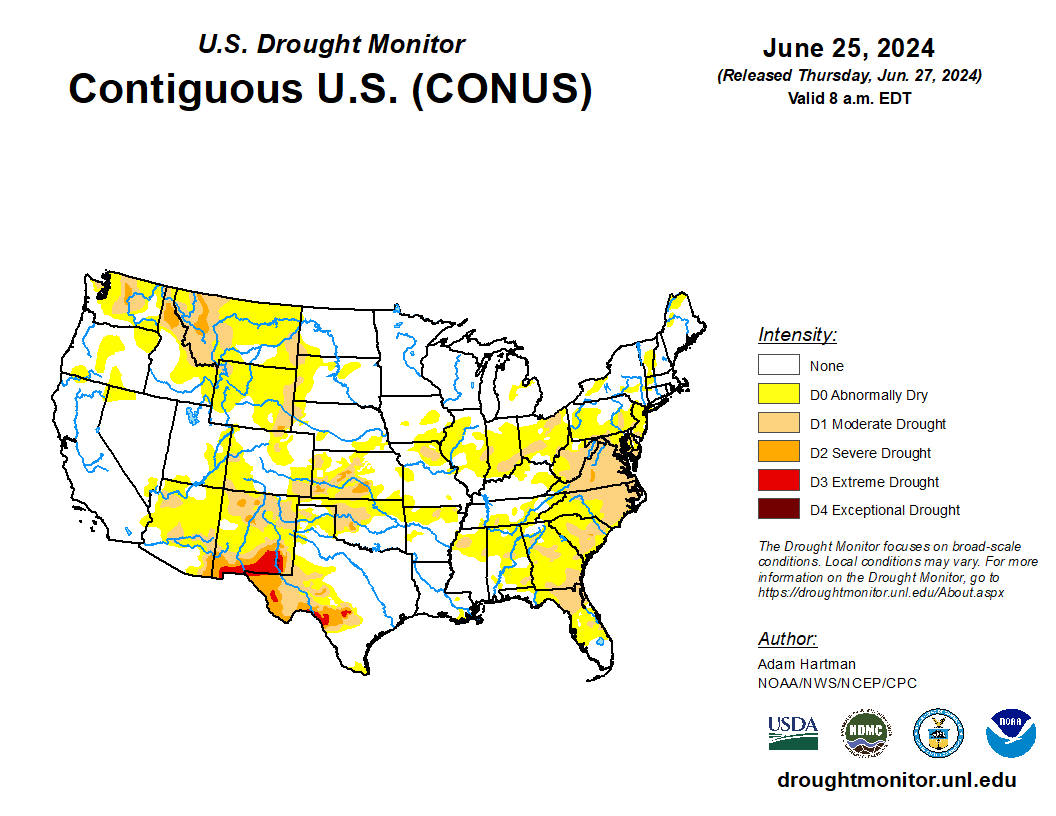
- In the Plains, widely scattered showers and thunderstorms have overspread the region, though temperatures, while not as hot as earlier in the week, remain above normal. Abnormally Dry (D0) conditions with pockets of Moderate Drought (D1) continue across the northern Plains while recent locally heavy rain netted drought improvement on the southern Plains.
- In the Corn Belt, a cold front has cleared the region followed by a welcome respite from this past week’s heat. Favorably drier weather across the northwestern Corn Belt is allowing saturated soils to dry and fieldwork to resume following recent excessive rain. On the other hand, 24-hour rainfall totals in the Ohio Valley associated with the front tallied less than half an inch, offering little relief from expanding Moderate Drought (D1).
- In the South, locally heavy showers are developing along the immediate Gulf Coast, while showers and thunderstorms are accompanying a cold front over the interior Southeast. Moderate Drought (D1) has rapidly developed from Virginia into northern Florida, exacerbated by recent excessive heat. Meanwhile, sunny skies are promoting fieldwork across the western Gulf Coast States, with significant drought reduction noted in southern Texas courtesy of recent heavy rain.
Outlook:
A strong cold front crossing the East Coast States is bringing an end to the recent eastern heat wave while generating much-needed showers on parched topsoils in the Mid-Atlantic and Southeast. Meanwhile, a developing low trekking along the Canadian border coupled with a trailing cold front will generate widespread showers and locally severe thunderstorms as it marches east across the Plains Friday, Midwest on Saturday, and Atlantic Coast States on Sunday. The two fronts combined will provide sorely needed rain (1-2 inches) in the Southeast but unwelcome 2-inch rainfall totals in the western Corn Belt. Farther west, precipitation will primarily be limited to monsoon showers in the Four Corners. The NWS 6- to 10-day outlook for July 2 – 6 calls for above-normal rainfall across the Four Corners and from the Northwest eastward across the Plains, Midwest, and New England. Conversely, drier-than-normal weather is expected over the Southeastern and Gulf Coast States and from central California into the Great Basin. Abnormal warmth is likely from California eastward to the central and southern Atlantic Coast, with the highest heat chances anchored over the Southeast and Gulf Coast States. Cooler-than-normal weather will be confined to the northwestern quarter of the nation and southern Arizona.