U.S. Weather/Crop Progress
Highlights:
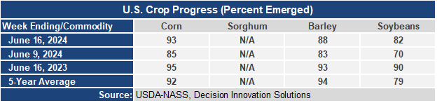
- 93% of the corn planted has emerged. This is 8 points higher than a week ago, 2 points behind last year, but 1 point ahead of the 5-year average. Soybean emergence is at 82%, up 12 points from last week, but 8 points behind last year, although 3 points ahead of the 5-year average.
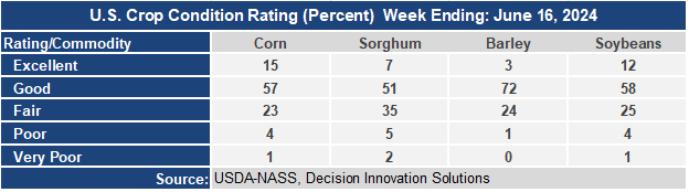
- The corn crop condition report has now dropped several points from the initial rating with the Good/Excellent rating now at 72%. The soybean condition rating is still at 72% G/E. The sorghum condition rating is now a couple points lower than last year’s rating. The barley condition rating of 75 G/E is well ahead of last year’s rating of 50.
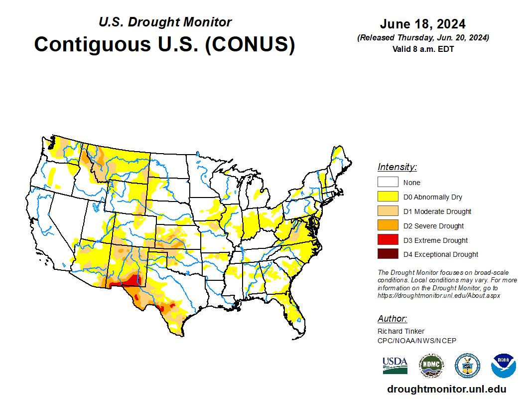
- In the West, dry and hotter weather is replacing the recently cooler conditions which featured mountain snow. Seasonal fieldwork continues to proceed without delay. The latest S. Drought Monitor indicates the region’s drought depiction remains unchanged from last week, which is typical for this time of year.
- In the Plains, a stationary front separates unseasonably chilly temperatures this morning in Montana and the Dakotas from building heat across the central and southern Plains. Some showers are developing along and north of the front, while dry weather is promoting rapid winter wheat harvesting and other seasonal fieldwork from Nebraska into Texas.
- In the Corn Belt, a stationary front bisecting the region is triggering showers and thunderstorms over the western and northern Corn Belt. In contrast, the heat wave continues south of the front from the middle Mississippi Valley into the Ohio and Tennessee River Valleys, where today’s highs in the middle 90s (°F) will exacerbate soil moisture losses.
- In the South, Tropical Storm Alberto moved ashore in northeastern Mexico, with deep tropical moisture well north of the storm’s center triggering locally heavy showers in southern Texas. Meanwhile, a disorganized system northeast of the Bahamas is being monitored for development as it approaches Florida. Otherwise, dry weather is promoting fieldwork but also increasing drought concerns from the Carolinas into the northern Delta.
Outlook:
A strong ridge of high pressure will maintain the current eastern heat wave into next week. For Thursday, the core of the heat will stretch from the Ohio Valley into New England, with highs expected to reach or top 95°F. Heading into the weekend, the high and its associated heat wave will shift southward, expand, and intensify, with 100-degree readings possible across the eastern Corn Belt and the middle Atlantic States. A cold front will provide showers and cooler temperatures across the Northeast, perhaps spilling into Maryland and Virginia early next week. Heat will also return across large sections of the Plains and West as the high expands westward, with triple-digit daytime highs likely by Sunday from southern Nebraska into Oklahoma and northern Texas. Highest rain chances will rim the strong high, with heavy showers and thunderstorms (1-2 inches, locally more) possible from Nebraska and South Dakota eastward into the Great Lakes and Northeast over the next three days. A weak tropical disturbance may also bring locally heavy showers to the Southeast, but significant tropical development is not expected. Seasonably sunny but hot weather is expected across much of the West. The NWS 6- to 10-day outlook for June 24 – 28 calls for near- or above-normal temperatures and rainfall across most of the country. Cooler-than-normal conditions will be confined to the Pacific Northwest, while drier-than-normal weather should be limited to an area stretching from northern California into the Great Basin.