U.S. Weather/Crop Progress
Highlights:
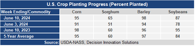
- Corn has now reached 95% of intended acreage planted which is consistent with the 5-year average for mid-June. Soybean planting progress is also moving along nicely and is now 3 points ahead of the 5-year average for the second week of June even if it lags a bit behind last year’s relatively fast pace.
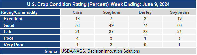
- The corn crop condition report held at a strong 74% Good/Excellent rating and well above last year’s G/E rating of 61. Soybean condition rating starts off the year strong at 72% G/E, well ahead of last year’s rating of 59. The sorghum condition rating is about the same as last year’s rating. The barley condition rating of 76 G/E is well ahead of last year’s rating of 58.
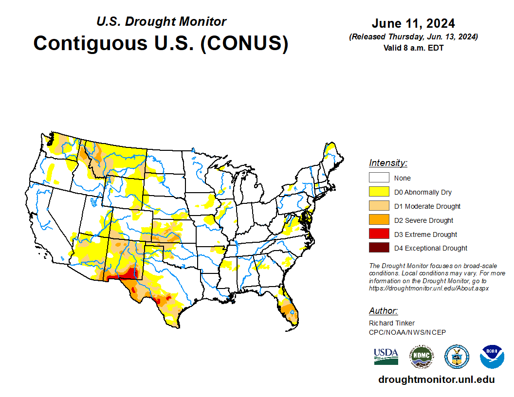
- In the West, a hot, dry regime is in place, except for somewhat cooler conditions near the Canadian border and along the immediate Pacific Coast. Although mostly sunny weather is promoting fieldwork and crop development, irrigation demands are increasing as topsoil experiences seasonal drying.
- In the Plains, hot weather prevails from Colorado and Kansas southward, allowing the winter wheat harvest to rapidly advance. By June 9, the wheat harvest in Oklahoma and Texas was 48 and 47% complete, respectively, versus 5-year averages of 17 and 39%. High temperatures on Thursday will top 100°F as far north as southeastern Colorado and central Kansas. Meanwhile, pleasant weather covers the northern Plains, where scattered showers are gradually ending.
- In the Corn Belt, spotty showers in northern corn and soybean production areas are interrupting an otherwise dry pattern. With planting of Midwestern summer crops nearly complete, producers are focusing on other activities, including—where applicable—starting the winter wheat harvest. By June 9, Missouri led the Midwest with 10% of its winter wheat acreage harvested, well ahead of the 5-year average of 4%. On that date, the wheat harvest was 6% complete in Illinois.
- In the South, torrential rain has ended across southern Florida, although showers and flash flood concerns linger. On June 12, rainfall totaled 6 to 10 inches in Florida locations such as Fort Lauderdale (9.54 inches), Pembroke Pines (7.92 inches), and Pompano Beach (6.44 inches). Elsewhere, building heat and dry conditions favor a rapid pace of fieldwork and crop growth, as well as winter wheat maturation and harvesting. Later today, high temperatures will reach or exceed 90°F throughout the region, except in the southern Appalachians, southern Florida, and the immediate Gulf Coast.
Outlook:
An early-season Midwestern heat wave will peak late in the weekend and early next week with temperatures ranging from 95 to 100°F, except in the upper Mississippi Valley. Similar temperatures (95 to 100°F) will be observed from the central and southern Plains into the middle and southern Atlantic States. However, the northern Plains and upper Midwest will escape the heat. Meanwhile, significant precipitation will be scarce for the next 5 days, except in selected areas. For example, locally heavy showers will linger across southern Florida, where an additional 2 to 6 inches of rain could fall atop already impressive totals. Farther north, 5-day rainfall could reach 1 to 3 inches across the northern and central Plains and the upper Midwest. Finally, tropical moisture may begin to overspread the western and central Gulf Coast States early next week. The NWS 6- to 10-day outlook for June 18 – 22 calls for near- or above-normal temperatures nationwide, except for cooler-than- normal conditions across portions of the northern High Plains, northern Great Basin, and the Northwest. Meanwhile, near- or above-normal rainfall across most of the country should contrast with drier-than-normal weather in the middle Atlantic States and environs, including the central Appalachians.