U.S. Weather/Crop Progress
Highlights:
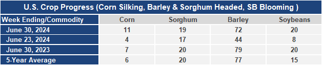
- 11% of the corn is silking which means the plants are entering the pollination stage. This is 7 points higher than a week ago, 4 points ahead of last year, and 5 points ahead of the 5-year average. Sorghum heading is at 19%, 1% behind last year and the 5-year average. Barley heading at 72% jumped 28 points this week but is 7 points behind last year and 5 points behind the 5-year average. Soybean blooming is at 20%, up 12 points from last week, even with last year, but 5 points ahead of the 5-year average.
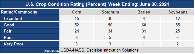
- The corn crop condition report slipped again with the Good/Excellent rating now at 67% although the excellent rating improved 1 point. The sorghum condition rating slipped to 58% G/E down 3 points from last week and now is just 3 points ahead of last year. The barley condition G/E rating slipped 4 points this week to 64 but is still 13 points ahead of last year’s rating. The soybean condition rating held steady at 67% G/E moving 1 point from the Good rating to the Excellent rating. The soybean G/E rating is 17 points higher than last year.
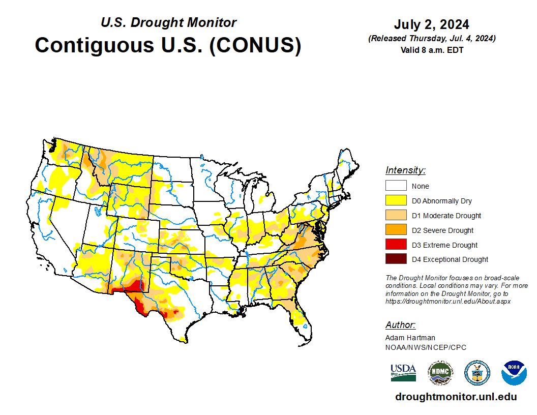
- In the West, a protracted heat wave is promoting a rapid pace of crop development but boosting irrigation demands. Currently, the most extreme heat is focused across the Pacific Coast States and the Desert Southwest, with Friday’s high temperatures expected to top 115°F as far north as the northern Sacramento Valley of California. In contrast, relatively cool conditions linger across the central Rockies and neighboring areas.
- On the Plains, below-normal temperatures prevail, except across the southern half of Texas. In fact, today’s high temperatures will remain below 80°F throughout the northern Plains, where recent crop growth has been slowed by cool, showery conditions. Currently, mostly dry weather has returned across the northern Plains, while showers have shifted southward, into Oklahoma and northern Texas.
- In the Corn Belt, a cold front is sparking showers and thunderstorms from the upper Great Lakes region into the lower Ohio Valley. Another round of cool weather trails the front, with Friday’s high temperatures expected to remain below 80°F in the upper Midwest. Meanwhile, warm, humid weather in the lower Midwest favors corn and soybean development, except in areas where soil moisture shortages exist.
- In the South, hot, humid weather is stressing pastures and summer crops in areas where moisture is lacking. At the end of June, more than one-third of the pastures were rated in very poor to poor condition in North Carolina (50%), South Carolina (41%), Georgia (40%), and Virginia (38%). Later Friday, high temperatures will reach or exceed 100°F in parts of Virginia and the Carolinas. Elsewhere, thundershowers are developing early today in parts of the mid-South.
Outlook:
Hurricane Beryl, which made landfall around daybreak on Friday near Tulum, Mexico, will weaken to tropical-storm strength while crossing the Yucatan Peninsula. However, Beryl may re-strengthen over the Gulf of Mexico before making a final landfall late Sunday or Monday in northeastern Mexico or coastal Texas. Storm-total rainfall associated with Beryl could reach 4 to 8 inches or more in southern Texas and environs. Meanwhile, cold fronts crossing the central and eastern U.S. will maintain unsettled, showery conditions from the Plains to the East Coast. Some of the heaviest rain, locally 1 to 3 inches or more, may fall in the Southeast, as well as portions of the central Plains, upper Midwest, and Northeast. In contrast, scorching hot, dry weather will dominate the West, with rampant 100-degree readings expected in all but coastal and high-elevation sites. Temperatures will frequently top 120°F at low-elevation locations in the Desert Southwest. The NWS 6- to 10-day outlook for July 10 – 14 calls for the likelihood of hotter-than-normal conditions nationwide, except for near- or below-normal temperatures from the southern Plains into the middle Mississippi Valley. Meanwhile, wetter-than-normal weather in the southern and eastern U.S. should contrast with below-normal precipitation from the Pacific Northwest into the upper Midwest.