
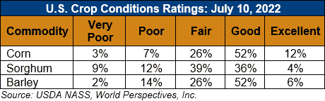
U.S. Weather/Crop Progress
U.S. Drought Monitor Weather Forecast: Over the next 5-7 days, it is anticipated that the monsoonal moisture will continue to bring rains throughout the Four Corners region. Active weather over the Midwest, Gulf Coast and Southeast will again bring widespread precipitation. Precipitation in the central Plains and northern Rocky Mountains will be minimal and dry conditions will continue to dominate the West as well as much of the southern Plains. Temperatures during this period will be well above normal over the western half of the U.S. with temperatures 6-9 degrees above normal while cooler-than-normal temperatures will be common over the eastern half with departures of 1-3 degrees below normal.
The 6-10 day outlooks show that the vast majority of the country has above-normal chances of recording temperatures that will be warmer than normal. The greatest probability of above-normal temperatures will be over the central to southern Plains. Alaska has above-normal chances of having cooler-than-normal temperatures during this time. The best chance of above-normal precipitation is over the Southwest and Southeast while much of the rest of the country will likely have below-normal precipitation, with the greatest chances in the Pacific Northwest and southern Plains.
Follow this link to view current U.S. and international weather patterns and future outlook: Weather and Crop Bulletin.