U.S. Weather/Crop Progress


Highlights:
- 46% of the corn is now in the dent stage or final ear-fill stage. This is 16 points higher than a week ago, even with last year, and 4 points ahead of the 5-year average. Sorghum coloring is at 48%, 3 points ahead of last year and 2 points ahead of the 5-year average. Barley harvest is underway with 47% harvested, up 17 points from last week, but behind last year and the 5-year average. Soybean pod set is at 90%, up 9 points from last week, even with last year, but 2 points ahead of the 5-year average.
- The corn crop condition fell 2 points this week with the Good/Excellent rating at 65%. A fall-off in crop condition with some hot, dry weather in the Midwest and Plains states is seasonally normal. Sorghum condition declined 1 point with the G/E category at 48%. 20% of sorghum is now rated poor to very poor condition due to excessive heat and dryness. The barley condition G/E rating fell 4 points to 65%. The soybean condition rating fell 1 point to 67% G/E.
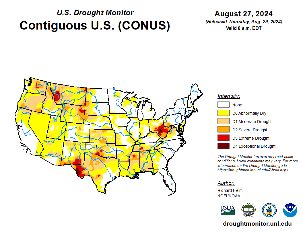
- In the West, cool weather lingers across the northern Rockies and interior Northwest. Elsewhere, late-season heat is building across portions of the Pacific Coast States and Desert Southwest, while monsoon-related showers continue in parts of the Southwest.
- On the Plains, scattered showers stretch from North Dakota to Colorado. The rain is causing minor small grain harvest delays on the northern Plains, but is generally benefiting rangeland, pastures, and immature summer crops. The unsettled weather separates cool conditions on the northern Plains from lingering heat across the southeastern half of the region. Thursday’s high temperatures will approach 100°F as far north as eastern Oklahoma.
- In the Corn Belt, warm but relatively tranquil weather prevails as one cold front weakens over the Ohio Valley, while another approaches the upper Midwest. Before weakening, the initial front had a history of producing locally severe thunderstorms, with peak wind gusts on August 28 topping 60 mph in Michigan locations such as Lansing and Saginaw, along with Toledo, Ohio. However, some immature summer crops have benefited from this week’s scattered showers.
- In the South, hot, humid weather persists, especially from the Mississippi Delta eastward. Thursday’s high temperatures should reach 100°F or higher as far north as the Tennessee Valley. Meanwhile, heavy showers over the Gulf of Mexico continue to periodically move inland, especially in coastal sections of Louisiana and Texas. The coastal showers are causing local harvest delays for crops such as rice.
Outlook:
A building ridge of high pressure over the western U.S. will lead to mostly dry weather and rising temperatures heading into the Labor Day weekend. By Sunday, temperatures could reach 100°F as far north as eastern Washington, while readings will top 110°F in parts of the Desert Southwest. Dry weather will extend eastward across the northern Plains. Farther east, unsettled, showery weather will gradually shift southward, as a cold front currently approaching the upper Midwest pushes toward the Gulf Coast. By Sunday, Midwestern showers will end, while rain will become oriented in a west- to-east band across the South. In fact, Southern showers will continue into next week, with 5-day rainfall totals reaching 1 to 3 inches in many locations, except for potentially higher amounts in southern Florida and coastal sections of Louisiana and Texas. The NWS 6- to 10-day outlook for September 3 – 7 calls for the likelihood of above-normal temperatures along and northwest of a line from south-central New Mexico to Lake Superior. Hotter-than-normal weather will also prevail along and near the Gulf Coast, but near- or below-normal temperatures will cover the remainder of the country, including the middle and northern Atlantic States and much of the Midwest. Meanwhile, near- or below-normal rainfall across most of the country should contrast with wetter-than-normal conditions from much of Texas to the southern Atlantic Coast.

