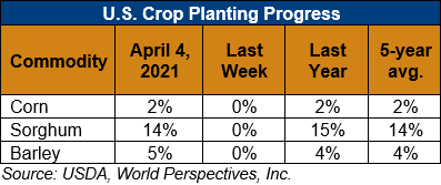
U.S. Weather/Crop Progress

U.S. Drought Monitor Weather Forecast: The National Weather Service Weather Prediction Center forecast for the next 5 days (April 8 through the 12) forecasts heavy rain and the potential for thunderstorms for the central U.S. As the storm system pushes eastward, chances increase for heavy rain and thunderstorms across the Upper Midwest, south-central, and southeastern U.S. In the Northwest, a storm moving in from the Pacific will bring colder than normal temperatures with snow likely falling in the Cascades and Northern Rockies and rain at lower elevations. In the Southwest and southern High Plains, warm, dry weather combined with gusty winds is expected to persist, leading to the potential continuation of dangerous fire weather conditions.
Moving into next week, the Climate Prediction Center six- to 10-day outlook (valid April 12 through April 16) favors above normal temperatures across the West, Northeast and Southeast, with the largest probabilities centered over the Great Basin and New England. Below normal temperatures are most likely across the Great Plains, Mississippi Valley and Alaska. The greatest probabilities of above normal precipitation are across the Southern Plains, Southeast and Mid-Atlantic states.
Follow this link to view current U.S. and international weather patterns and future outlook: Weather and Crop Bulletin.
