U.S. Weather/Crop Progress
Highlights:
- In the West, a few showers are arriving in the Pacific Northwest. Elsewhere, warm, dry weather is promoting fieldwork and crop development. On March 31, one-fifth (20%) of California’s winter wheat had headed, well ahead of the 5-year average of 7%. On the same date, 6% of Arizona’s intended cotton acreage had been planted.
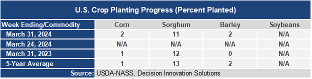
- In the Plains states, dry weather accompanies a warming trend. In fact, temperatures have rebounded to above-normal levels across the High Plains. Current conditions favor a rapid pace of fieldwork, including early season plating activities. By March 31, spring wheat planting was just getting underway (1% complete) in South Dakota, while 2% of the corn had been planted in Kansas.
- In the Corn Belt, Tuesday thunderstorms resulted in scattered wind and hail damage in the Ohio Valley. Currently, cool, breezy conditions have engulfed the Midwest, with rain and snow showers lingering from the Mississippi Valley eastward. Recent and ongoing storminess has improved topsoil moisture but has curtailed fieldwork. On March 31, Iowa led the Midwest with topsoil moisture rated 59% very short to short.
- In the South, locally severe thunderstorms are sweeping into the Atlantic Coast States. Meanwhile, cool, dry, breezy weather covers much of the remainder of the region, allowing spring planting activities to resume as field conditions permit. On March 31, Louisiana led the U.S. with 51% of its intended rice acreage planted.
Outlook:
A low-pressure system currently centered over Lake Michigan will meander eastward, reaching the northern Atlantic Coast late in the week. After winds diminish, late-week frost and freezes may occur as far south as the southern Appalachians and the Tennessee Valley. Farther west, a new round of Pacific storminess will quickly spread inland across the West. In advance of the Western rain and snow showers, warm air will surge northward across the Plains. During the weekend, however, rain will return across the nation’s mid-section, spreading as far east as the Mississippi Valley by Sunday. The NWS 6- to 10-day outlook for April 8 – 12 calls for the likelihood of near- or above-normal temperatures nationwide, except for cooler-than-normal conditions in parts of southern Florida and the Southwest. Meanwhile, above normal precipitation in most areas east of a line from southern California to Minnesota should contrast with drier-than-normal weather in northern and central California and the Northwest, along with the Great Basin and northern sections of the Rockies and High Plains.