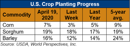
U.S. Weather/Crop Progress

U.S. Drought Monitor Weather Forecast: The nearby weather outlook features an active storm pattern, with the greatest precipitation expected over the Lower Mississippi Valley, into the Ohio River Valley and into the Southeast, including Florida. Some coastal precipitation is expected over portions of Washington and into Oregon, but most of the rest of the West is not anticipating much precipitation. Temperatures during this time will be cooler than normal over the East and especially the Northeast, where departures will be in the range of 9-12 degrees below normal. The West and Southwest are anticipated to be the warmest with departures of 9-12 degrees above normal.
The 6-10-day outlooks show a higher probability of drier than normal conditions over much of the West and into the Plains and Southeast as well as Alaska. In contrast, there is a higher probability of wetter than normal conditions over the Midwest and Northeast. Temperatures during this time show that the greatest probability of warmer than normal temperatures is over the Southwest with much of the western half of the United States having a greater likelihood of warmer than normal temperatures. Much of the Midwest, the Northeast, the Mid-Atlantic and eastern Alaska have the best chances of recording below-normal temperatures, with the highest probabilities in the Northeast.
Follow this link to view current U.S. and international weather patterns and future outlook: Weather and Crop Bulletin.
