U.S. Weather/Crop Progress


Highlights:
- 65% of the corn is now harvested, up 18 points from last week, 10 points ahead of last year and 13 points ahead of the 5-yr average. Sorghum harvest is at 64%, 1 point ahead of last year and 3 points ahead of the 5-year average. Barley harvest is complete. Soybean harvest is now at 81% completed, up 14 points from last week, 9 points ahead of last year and 14 points ahead of the 5-year average.
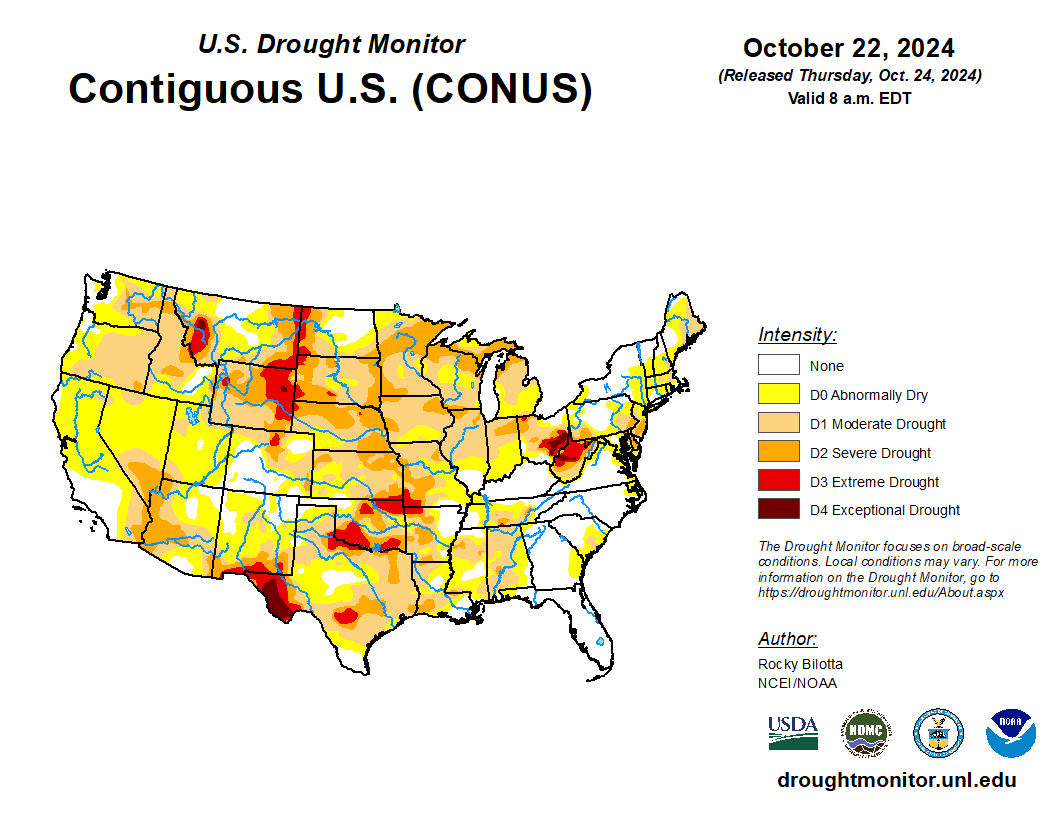
- In the West, lingering warmth is mostly confined to the Four Corners States. Meanwhile, below-normal temperatures are in place across the Northwest, extending into northern sections of California and the Great Basin. Despite the turn toward cooler weather in the Northwest, Wyoming led the region on October 20 with topsoil moisture rated 93% very short to short, followed by Washington (72%) and Oregon (70%).
- On the Plains, widespread cloudiness covers much of Montana, Wyoming, and the Dakotas, although only light, scattered showers are occurring. Meanwhile, record-setting warmth across the southern half of the region is leading to further reductions in moisture availability for recently planted winter wheat. On October 23, daily-record high temperatures were established in Texas locations such as Wichita Falls (95°F), Lubbock (93°F), and Abilene (91°F).
- In the Corn Belt, mild, dry weather is allowing many Midwestern producers to achieve an early completion of this year’s soybean harvest. Nationally, 81% of the soybeans had been harvested by October 20, well ahead of the 5-year average pace of 67%. Meanwhile, late-summer and autumn drought has adversely affected many Midwestern pastures, which on October 20 were rated 66% very poor to poor in Ohio, along with 57% in Nebraska and 51% in South Dakota.
- In the South, very warm, dry weather prevails. In fact, Thursday’s high temperatures should top 90°F in parts of the western Gulf Coast region. Many producers are actively harvesting summer crops and planting winter grains and cover crops, amid ideal conditions, aside from diminishing soil moisture reserves. By October 20, topsoil moisture rated very short to short had climbed above 50% in all Southern States, except Florida (20% very short to short), Virginia (26%), North Carolina (38%), and Kentucky (42%).
Outlook:
Many areas of the country – including the Plains, South, and Atlantic Coast States—will remain mostly dry during the next 5 days. However, parts of the Midwest will receive generally light rain, mainly later today into Friday, followed by significant precipitation in the Pacific Northwest during the weekend. By early next week, a storm system moving inland across the western U.S. will produce some rain and snow. Meanwhile, temperatures will fluctuate as fast-moving cold fronts cross the nation, with some of the coldest air of the season arriving early next week in the West. The NWS 6- to 10-day outlook for October 29 – November 2 calls for the likelihood of above-normal temperatures in most areas from the Plains to the East Coast, while cooler-than-normal conditions will cover the West. Meanwhile, near- or above-normal precipitation across most of the country should contrast with drier-than-normal weather in parts of California and the middle and northern Atlantic States. The upper Midwest will have the greatest likelihood of experiencing wet weather.

