
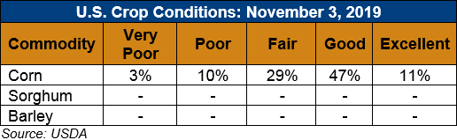
U.S. Weather/Crop Progress
U.S. Drought Monitor Weather Forecast: The NWS WPC 7-Day Quantitative Precipitation Forecast (QPF) calls for moderate-to-heavy accumulations ranging from 1 to 4 inches across a swath extending from northern Texas to Kentucky later this week. Further south, light-to-moderate accumulations (1-to-2 inches) are expected along the Gulf Coast and in south Texas. Along the Great Lakes and the Northeast, periods of precipitation (accumulations generally <1 inch liquid), including some heavy lake-effect snowfall, are expected. Out West, primarily warm and dry conditions will prevail with the exception of northern portions of the Pacific Northwest and northern Rockies that may see periods of mountain snow.
The CPC 6–10-day Outlook calls for a high probability of above-normal temperatures west of the Rockies while areas east of the Rockies are expected to be below normal. In terms of precipitation, there is a moderate-to-high probability of below-normal levels across most of the West including the Intermountain West, Great Basin, California, and the Pacific Northwest while there is a moderate probability of above-normal precipitation in eastern Montana and western portions of the northern Plains. Likewise, above-normal precipitation (moderate probability) is expected in the southern tier from Texas to Florida and extending up the Eastern Seaboard.
Follow this link to view current U.S. and international weather patterns and future outlook: Weather and Crop Bulletin.