
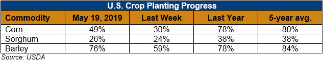
U.S. Weather/Crop Progress
U.S. Drought Monitor Weather Forecast: Next week (May 23-28) will largely see a repeat of this week’s weather pattern. A couple upper-level Pacific weather systems will move across the West, then roar out of the Southwest, across the Plains, to the Great Lakes, dropping several inches of rain across parts of the southern to central Plains and Midwest. Half an inch to locally 2 inches of precipitation are expected across much of the West, except little to no precipitation is forecast for southern portions of the Southwest and parts of the Pacific Northwest. The weather systems will keep western temperatures cooler than normal, while the North Atlantic High will keep temperatures warmer than normal across the southeastern third of the CONUS. Little to no precipitation is predicted for much of the southern Plains to Southeast, although the western Carolinas might see up to an inch. Over an inch of precipitation is expected for northern portions of the Northeast, while southern portions should receive half an inch or less.
For May 29-June 5, more of the same. Odds favor cooler-than-normal temperatures from the Southwest to the Great Lakes, while warmer-than-normal temperatures are expected for the Southern Plains to Mid-Atlantic region and the West Coast to northern Rockies. Odds favor below-normal precipitation for the Gulf of Mexico and Southeast coastal states, Washington and Oregon in the Pacific Northwest, parts of New Mexico, and the North Dakota and Minnesota D0 areas. Odds favor wetter-than-normal conditions for the rest of the West, and most of the Great Plains to Northeast.
Follow this link to view current U.S. and international weather patterns and future outlook: Weather and Crop Bulletin.