U.S. Weather/Crop Progress
Highlights:
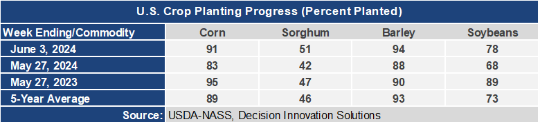
- Planting progress for the end of May is at or slightly ahead of the 5-year average nationally and in most of the major corn producing states. Soybean planting progress is also moving along nicely and with a period of warm, dry weather ahead for most of the areas that still need planted, many producers will wrap of planting this week if they haven’t already finished.
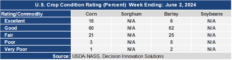
- The first crop condition report of the year was released for corn and barley. Corn is rated 75% G/E, and that is 11 points higher than this time last year. The majority of the fair ratings are due to too much rain and ponding in fields.
- In the West, an early-season heat wave is boosting maximum temperatures to 110°F or higher in the Desert Southwest, extending as far north as southern Nevada. Triple-digit (100-degree) heat is also occurring in much of California’s Central Valley. Meanwhile, warmer weather in the Northwest favors a rapid pace of development for winter wheat and spring-sown crops. In Washington, 69% of the winter wheat had headed by June 2, versus the 5-year average of 49%.
- In the Plains, warm, dry weather is promoting a rapid pace of fieldwork and crop development. By June 2, the winter wheat harvest was well underway on the southern Plains, led by Texas (33% complete, ahead of the 5-year average of 27%) and Oklahoma (22% complete, versus the average of 6%). Hot weather lingers across the southern Plains, with today’s high temperatures expected to reach or exceed 100°F in much of western Texas.
- In the Corn Belt, cool, breezy, mostly dry weather prevails, following an extended period of unsettled weather. Early Wednesday, a few showers lingered across the Great Lakes region. As Midwestern fields begin to dry, producers should soon be able to plant any remaining corn and soybean acreage. Drier weather should also favor Midwestern winter wheat maturation, with harvest just getting underway (5% complete on June 2 in Missouri).
- In the South, showers linger from the Appalachians and the central Gulf Coast region eastward to the Atlantic Seaboard. However, rain continues to bypass Florida’s peninsula, where crops—including citrus—have required heavy irrigation in recent weeks due to hot, dry conditions. Summer-like heat also prevails in the western Gulf Coast region, where today’s high temperatures in southern Texas should approach or reach 100°F.
Outlook:
Starting Thursday, thundershowers in the eastern U.S. will occur in advance of a cold front moving toward the Atlantic Coast. During the next few days, a period of pleasantly cool, breezy weather will settle across areas from the northern Plains into the Northeast. However, some areas in the Great Lakes States may experience occasional showers. Meanwhile, scattered showers and thunderstorms will develop late in the week near the boundary between cool air in the North and early-season heat across the Deep South. Five-day rainfall totals could reach 1 to 3 inches from the eastern slopes of the central and southern Rockies and the southern Appalachians. Meanwhile, blazing heat will persist through the weekend from the Desert Southwest to the southern Atlantic Coast, with temperatures routinely topping 100°F into the weekend across much of western Texas. Late-week temperatures will exceed 110°F in parts of the Desert Southwest. The NWS 6- to 10-day outlook for June 11 – 15 calls for the likelihood of near- or above-normal temperatures nationwide, except for cooler-than-normal conditions from the mid-South into the Ohio Valley and interior Southeast. Meanwhile, near- or below-normal rainfall across most of the country should contrast with wetter-than-normal weather from the Great Basin to the southern High Plains.