
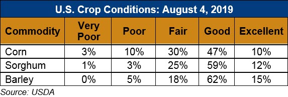
U.S. Weather/Crop Progress
U.S. Drought Monitor Weather Forecast: During the next 5 days (August 8 – 13, 2019) should bring heavy rains of 1 to locally 4 inches to portions of western New Mexico, a swath through the central Plains, and many locations across upstate New York and southern Maine. Most of the area from northern Idaho eastward through northern Montana are expecting 1 to 2 inches, as are most of the Dakotas and scattered patches across the Pacific Northwest. Other areas of dryness across the contiguous 48 states should get lesser amounts. Locally up to an inch is expected in the Southeast and southern New England, and little or none is anticipated in most of the new D0 area in the southern Plains from central Kansas through Oklahoma and Texas. Temperatures are forecast to be a few degrees above normal in the southern Plains and the Southeast while subnormal temperatures should extend from the northern half of the Plains to the Pacific Ocean.
The CPC 6-10-day outlook (August 14 -18, 2019) favors above-normal precipitation in east-central Alaska, the Pacific Northwest, the central and northern Plains, the lower Mississippi Valley, and the Southeast. Meanwhile, subnormal precipitation is expected in southern and southeast Alaska, the eastern Great Basin, the Four Corners States, most of Texas, and the Northeast. Temperatures should average below normal from the Intermountain West eastward through the Midwest and Northeast, and across east-central Alaska. Farther south, southern and southeastern Alaska have enhanced chances of warmer than normal weather, along with the Pacific Coast and a large swath from the Great Basin through the Four Corners States, central and southern High Plains, lower Mississippi Valley, and Southeast. The highest likelihood for hotter than normal weather are across most of Texas and the lower Southeast.
Follow this link to view current U.S. and international weather patterns and future outlook: Weather and Crop Bulletin.