U.S. Weather/Crop Progress
Highlights:
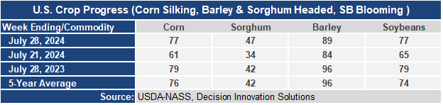
- 77% of the corn is silking which means that probably half the corn crop has completed pollination and is moving into the dough or ear-fill stage. This is 16 points higher than a week ago, 2 points behind last year, and 1 point ahead of the 5-year average. Sorghum heading is at 47%, 5 points ahead of last year and the 5-year average. Barley heading at 89%, increased 5 points this week but is now 7 points behind last year and 7 points behind the 5-year average. Soybean blooming is at 77%, up 12 points from last week, 2 points behind last year, but 3 points ahead of the 5-year average.
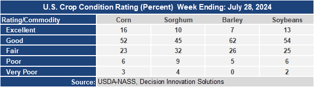
- The corn crop condition held steady this week with the Good/Excellent rating remaining at 68%. Individual state reports show the crop deteriorating in the north and western parts of the Cornbelt but improving in the central and eastern Cornbelt. The barley condition G/E rating declined 5 points to 69%. The soybean condition rating dropped 1 point at 67% G/E.
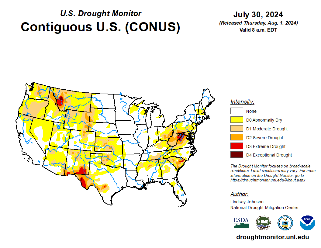
- In the West, hot weather has returned, with Thursday’s high temperatures expected to top 100°F as far north as southeastern Washington. Meanwhile, the Southwestern monsoon circulation is producing a few showers, mainly in Arizona and New Mexico. Nearly 100 Western wildfires are in various stages of containment, with northern California’s Park Fire, near Chico, having burned more than 391,000 acres of vegetation and having damaged or destroyed nearly 500 structures.
- On the Plains, hot weather prevails, despite the passage of a weak cold front through parts of Kansas and Oklahoma. South of the front, Thursday’s high temperatures should range from 100 to 105°F on the southern Plains. However, temperatures could also reach 100°F as far north as eastern Montana. The hot, mostly dry conditions favor fieldwork, including small grain harvesting, but are reducing soil moisture for rangeland, pastures, and immature summer crops.
- In the Corn Belt, an active cold front is producing widespread showers and thunderstorms from the Mississippi Valley eastward. Aside from isolated wind and hail damage, along with pockets of flash flooding, rain is benefiting reproductive to filling corn and soybeans. Additionally, temperatures remain favorable for Midwestern summer crops, except in the southwestern corner of the Corn Belt.
- In the South, hot, humid weather is promoting a rapid pace of crop development. Thursday’s high temperatures should generally range from 95 to 100°F in non-coastal, low-elevation sites. Lingering drought is primarily confined to the northern and interior sections of the region, with topsoil moisture in Virginia rated 49% very short to short on July 28.
Outlook:
Except from the Midwest into the Northeast, hot weather will span much of the country during the next several days. Frequent readings of 100°F or higher will occur at lower elevations of the West, as well as the central and southern Plains and mid-South. Meanwhile, a final round of Midwestern showers will mostly end on Friday, although rain may linger into Saturday in parts of the Ohio Valley. Eastern rain will be slower to depart, with showers continuing through the weekend—and into early next week across the lower Southeast. Farther west, only spotty showers will occur during the next 5 days in the western and central U.S., with some of the most substantial rain (locally 1 to 2 inches) associated with the Southwestern monsoon circulation. Late in the weekend and early next week, thunderstorms may erupt across the northern Plains and upper Midwest, as substantially cooler air begins to surge southward. The NWS 6- to 10-day outlook for August 6 – 10 calls for below-normal temperatures across the North, from eastern Montana to New England, while hotter-than-normal conditions will cover the southern half of the U.S. and the Far West. Meanwhile, near- or above-normal rainfall can be expected nationwide, with central sections of the Rockies and High Plains having the greatest likelihood of experiencing wet weather.