U.S. Weather/Crop Progress
Highlights:
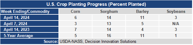
- In the West, frost and freezes were reported Wednesday morning in parts of the Pacific Northwest, west of the Cascades. Chilly conditions extend eastward to the northern Rockies—but developing warmth across the southern half of the region, from California to the central and southern Rockies, favors fieldwork and crop growth. In California, 55% of the winter wheat had headed by April 14, ahead of the 5-year average of 34%.
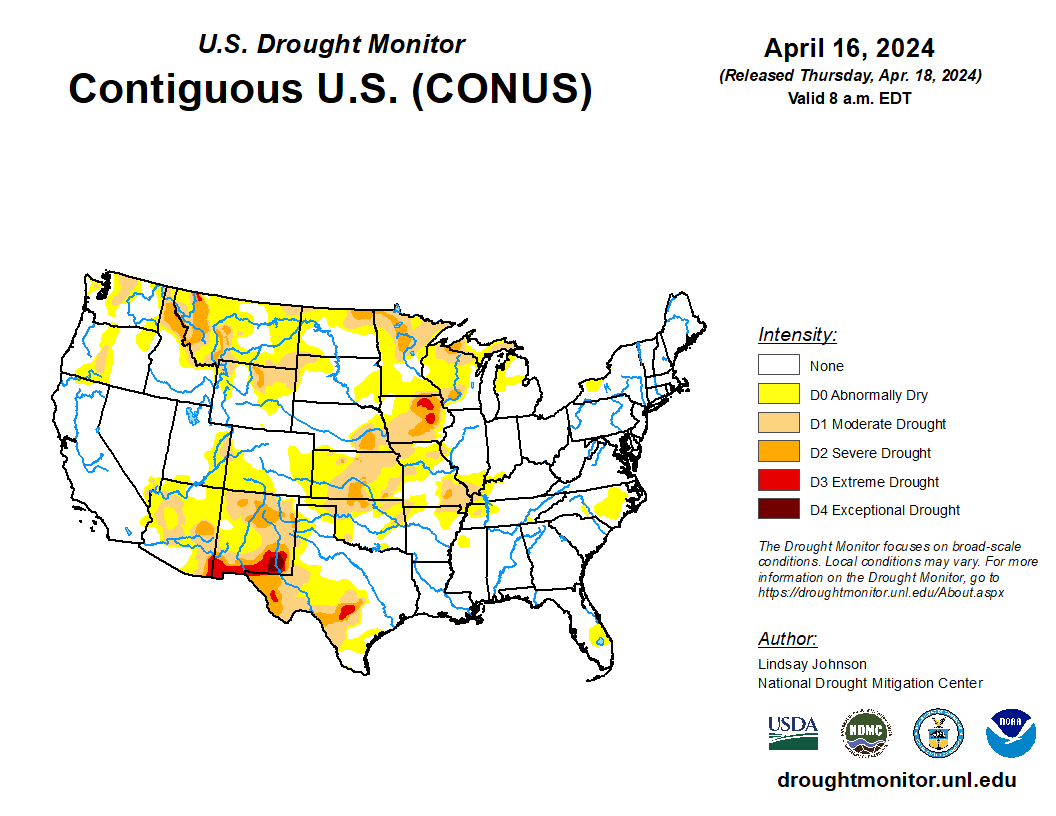
- In the Plains, cool air is in place across Montana and the Dakotas, while warm weather continues farther south. Emerging drought on the central Plains remains a significant concern for winter wheat, with the portion of the crop in Kansas rated in good to excellent condition falling from 49 to 43% during the week ending April 14.
- In the Corn Belt, cool, breezy, showery weather prevails across the upper Midwest in the wake of Wednesday night’s severe weather outbreak, which produced high winds, large hail, and isolated tornadoes in parts of Iowa, northern Missouri, eastern Nebraska, northwestern Illinois, and southern Wisconsin. Warmth lingers in the southern and eastern Corn Belt, although wet soils continue to limit fieldwork.
- In the South, very warm, mostly dry weather favors fieldwork and crop development, despite widespread cloudiness. By April 14, Arkansas led the U.S. with 26% of its intended soybean acreage planted, well ahead of the 5-year average of 8%.
Outlook:
A low-pressure system traversing the upper Great Lakes region will weaken, although rain showers will linger across parts of the Midwest and East. A trailing disturbance will maintain unsettled, showery weather for the remainder of the week in parts of the central and eastern U.S. However, rain should largely bypass the Gulf Coast region and the southern Atlantic States. In the wake of the showery weather, cool air will spread southward. During the weekend, widespread sub- freezing temperatures will cover the northern Plains and upper Midwest, with readings below 32°F expected as far south as eastern Colorado and western Kansas. In contrast, most areas west of the Rockies will experience an extended spell of warm, dry weather, with temperatures rising to 95°F or higher in parts of the Desert Southwest. The NWS 6- to 10-day outlook for April 22 – 26 calls for the likelihood of near- or below-normal temperatures in much of the eastern U.S., while warmer-than- normal weather will prevail in the eastern Gulf Coast region, including Florida, and west of a line from central Texas to Upper Michigan. Meanwhile, near- or above-normal precipitation across most of the country should contrast with drier-than-normal conditions in the Pacific Northwest, the lower Great Lakes region, and the Northeast.